Click to visit the main New York Public Library Homepage
The New York Public Library
Digital Collections
About Digital Collections
Browse
Search only public domain materials
Items
Collections
Divisions
Home
Search
Browse
About
Search only public domain materials
Items
Collections
Divisions
Digital Collections
Using Images
Using Data
Search
Filtered keyword search
Show filters
Hide filters
Show Only Public Domain
topic
Real property
6
Landowners
2
Railroads
2
Administrative and political divisions
1
Cemeteries
1
More
Less
name
Robinson, E. (Elisha)
4
E. Robinson Co
2
Pidgeon, R. H. (Roger H.)
2
Beers & Lanagan
1
Beers, D. G. (Daniel G.)
1
More
Less
collection
Maps of North America
8
Atlases of New York City
4
Atlases of the United States
2
place
New York (State)
4
Massachusetts
3
Staten Island (New York, N.Y.)
3
New England
2
New York (N.Y.)
2
More
Less
genre
Maps
14
Atlases
2
Cadastral maps
1
publisher
publisher not identified
3
E. Robinson Co
2
Robinson, E
2
E. Belcher Hyde
1
Beers & Lanagan
1
More
Less
division
Map Division
14
type
x
cartographic
Date Range
to
14 results found for:
x
LOWELL
Filtering on:
x
Type
: cartographic
Sort by:
Relevance
Title
Date created
Date digitized
Sequence
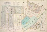
Plan of
Lowell
Cemetery
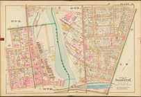
Map of the Boston &
Lowell
R.R. system
note:
… of the Boston &
Lowell
R.R.
Plan of the town of
Lowell
and Belvidere
The northern route from Bosto…
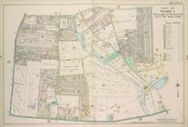
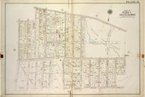
Plate 7, Part of Ward 1: [Map…
…. Donald Ave.,
Lowell
St
… bounded by
Lowell
St., N
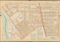
Plate 8, Part of Wards 1 & 2:…
m
… between Salem,
Lowell
…, Pelton Ave (
Lowell
Ave
New map of Massachusetts
note:
… -- Springfield --
Lowell
.
m
Map of Mahoning County, Ohio …
abstract:
… --
Lowell
[and] McGills
m
Map of Garrard and Lincoln co…
abstract:
… Lick,
Lowell
, Kings
Queens, Vol. 1, Double Page P…
collection:
….,
Lowell
Ave., Longfellow
End of results
|
Top