Click to visit the main New York Public Library Homepage
The New York Public Library
Digital Collections
About Digital Collections
Browse
Search only public domain materials
Items
Collections
Divisions
Home
Search
Browse
About
Search only public domain materials
Items
Collections
Divisions
Digital Collections
Using Images
Using Data
Search
Filtered keyword search
Show filters
Hide filters
Show Only Public Domain
topic
Real property
5
Surveys
4
Railroads
3
Geology
2
History
2
More
Less
name
Robert de Vaugondy, Gilles, 1688-1766
5
United States. Surveyor General for Ohio, Indiana and Michigan
5
American Civil War (1861-1865)
2
Haussard, C
2
Lyon, Lucius, 1800-1851
2
More
Less
collection
Maps of North America
31
Lawrence H. Slaughter Collection of English maps, charts, globes, books and atlases
5
Atlases of the United States
1
John H. Levine Collection
1
place
United States
8
Michigan
6
Ohio
6
Pennsylvania
6
Middle Atlantic States
5
More
Less
genre
Maps
38
Cadastral maps
2
Geological maps
2
Atlases
1
Bathymetric maps
1
More
Less
publisher
publisher not identified
7
Surveyor General's Office?
3
s.n
3
s.n.,
3
Board of Public Works of Virginia
1
More
Less
division
Map Division
38
type
x
cartographic
text
1
Date Range
to
38 results found for:
x
Ohio River
Filtering on:
x
Type
: cartographic
Sort by:
Relevance
Title
Date created
Date digitized
Sequence
… of the
Ohio
River
…
abstract:
… of mouth of the
Ohio
River
… on the lower
Ohio
…
abstract:
… to the
Ohio
River
.
m
A new map of the western
rivers
, or
note:
… Court of
Ohio
."…
A sketch of the Cherakee boun…
abstract:
…
Ohio
and Mississippi
Rivers
where Kentucky
Fourteenth l.h. district
note:
… extends, on the
Ohio
River
… &
Ohio
Rail Way …
abstract:
… Richmond, Va., to the
Ohio
River
along the route
… Virginia and the
Ohio
River
Trans-Flat-Top Land Associati…
abstract:
…. and
Ohio
River
(scale 24
… de l'
Ohio
, la Nlle
note:
… to the Mississippi
River
.
… comprend le cours de l'
Ohio
… de l'
Ohio
, la Nlle
note:
… to the Mississippi
River
.
Map of Port-Lawrence & Vistul…
abstract:
…
River
from its mouth
Survey of the mouth of Clinton
River
, Michigan …
…
River
,
Ohio
St., Lake
Plan of part of Weverton
note:
… the Potomac
River
and by the Chesapeake and
Ohio
Canal.
… on the
River
Ohio
.
Plan of the remains of some a…
abstract:
… and
Ohio
Rivers
. From
… nec non Fluvii
Ohio
abstract:
…. John's
River
up "Alatamaha"
River
, along
… of eastern
Ohio
, New York
note:
… of the Clarion
River
, situated
Ohio
lands to be sold by Irving Embree
abstract:
… the
Ohio
and Hocking
Rivers
m
A map of Cabotia: comprehendi…
note:
… of the
river
St. Lawrence from
Map of the surveyed part of I…
abstract:
… of the Mississippi
River
-- Map
m
The Wyoming Coal Field and it…
note:
… and eastern
Ohio
, and southern
A Tracing of parts of the states of
Ohio
, N.Y
abstract:
Covers northeastern
Ohio
, northwestern Pa
Map of the boundary line betw…
Part of North America: compre…
collection:
…,
rivers
, bays, roads
G. Woolworth Colton's map of …
note:
…, Kentucky, and
Ohio
Map of the northern peninsula…
abstract:
… for
rivers
, islands, and bays
Diagram of the state of Michi…
Sketch of the public surveys …
abstract:
Shows township grid for Michigan, names for
rivers
Diagram of part of the State …
abstract:
Also shows township grid, some
rivers
Plan of the western seat of w…
note:
…, Indiana,
Ohio
, Virginia
m
…
rivers
Map of the great north west: …
note:
… to Columbus,
Ohio
, and from St
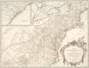
A Map of the British and Fren…
collection:
… the course of the
Rivers
Ohio
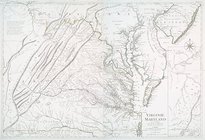
Virginie, Maryland : en 2 feu…
note:
… the confluence of the
Ohio
and Kenawha
rivers
.
m
…,
Ohio
, Virginia and West
note:
…, and
rivers
.
… de l'
Ohio
, la Nlle
note:
… to the Mississippi
River
. …
End of results
|
Top