Click to visit the main New York Public Library Homepage
The New York Public Library
Digital Collections
About Digital Collections
Browse
Search only public domain materials
Items
Collections
Divisions
Home
Search
Browse
About
Search only public domain materials
Items
Collections
Divisions
Digital Collections
Using Images
Using Data
Search
Filtered keyword search
Show filters
Hide filters
Show Only Public Domain
topic
History
6
Landowners
6
Administrative and political divisions
5
Real property
5
Colonies
2
More
Less
name
Jefferys, Thomas, -1771
6
Fry, Joshua, approximately 1700-1754
5
Jefferson, Peter, 1708-1757
5
Mitchell, John, 1711-1768
4
Moll, Herman, -1732
4
More
Less
collection
Maps of North America
23
Lawrence H. Slaughter Collection of English maps, charts, globes, books and atlases
11
Bancker plans
1
Cartographic materials from the Emmet collection of manuscripts etc. relating to American history
1
I. N. Phelps Stokes Collection of American Historical Prints
1
More
Less
place
North America
7
Virginia
7
North America -- Maps -- Early works to 1800
6
Great Britain
5
Great Britain -- Colonies -- America -- Maps -- Early works to 1800
5
More
Less
genre
Maps
41
Manuscript maps
3
Surveys
3
Cadastral maps
1
Plans
1
More
Less
publisher
Edward Wells
2
Printed at the expence of the Society for the encouragement of learning, by S. Richardson ..
2
Printed for Robt. Sayer at No. 53 in Fleet Street, & Thos. Jefferys at the corner of St. Martins Lane, Charing Cross
2
Printed for Robt. Sayer at No. 53 in Fleet Street, & Thos. Jefferys at the corner of St. Martins Lane, Charing Cross,
2
... Published according to Act of Parliament by Thos. Jefferys, geographer to His Royal Highness the Prince of Wales at the corner of St. Martins Lane, Charing Cross,
1
More
Less
division
Map Division
36
Schomburg Jean Blackwell Hutson Research and Reference Division
2
Manuscripts and Archives Division
1
Wallach Division: Art & Architecture Collection
1
Wallach Division: Print Collection
1
type
x
cartographic
still image
1
Date Range
to
41 results found for:
x
Plantations
Filtering on:
x
Type
: cartographic
Sort by:
Relevance
Title
Date created
Date digitized
Sequence
… and the adjacent
plantations
…
abstract:
Shows:
plantations
, churches, forts, swamps
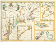
Map of Rhode Island and Providence
Plantations
…
note:
…. & Providence
Plantations
.
… and Providence
plantations
topic:
Plantations
m
Town site of La Gloria: looki…
collection:
Town site and
plantations
of La Gloria
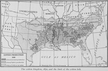
The cotton kingdom, 1850, and…
topic:
Cotton
plantations
…
plantations
of the English
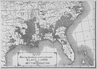
Map showing the relation exis…
topic:
Cotton
plantations
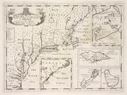
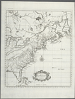
A new map of the English
plantations
A new map of Virginia
note:
…
plantations
in America.
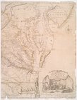
Virginia and Maryland
note:
…, and
plantations
.
…
plantations
of the English
…
plantations
of the English
…
plantations
of the English
m
…, and Providence
Plantations
…
m
A map of the British and Fren…
Lloyd's map of the lower Miss…
note:
…
plantations
, cities, towns
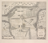
Plan of the siege of Charlest…
abstract:
…,
plantations
in "Gibbes Landing
Extract from a map of the Bri…
note:
… for Trade and
Plantations
m
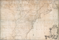
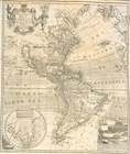
A map of the most inhabited p…
abstract:
…, for Trade and
Plantations
m
A map of the British and Fren…
m
A map of the most inhabited p…
note:
…, for Trade and
Plantations
A map of the British and Fren…
m
A map of the most inhabited p…
note:
…, for Trade and
Plantations
The English Empire in America…
note:
…
Plantations
on the continent
A New map of Virginia.
collection:
The history of the British
plantations
A map of the most inhabited p…
note:
…, for Trade and
Plantations
m
A map of South Carolina and a…
A map of the most inhabited p…
note:
…, for Trade and
Plantations
A new and correct map of Amer…
collection:
The history of the British
plantations
A topographical map of the no…
note:
… &
Plantations
. by W.M Faden
New map of Charleston Harbor:…
Charts and plans illustrating…
m
A map of South Carolina and a…
m
Part of Kip's Bay, north east
note:
Includes Gregory's
plantation
.
…, and
plantation
of Houghton
A map of the British-
plantations
collection:
A map of the British-
plantations
on the continent
m
…'s
plantation
, in Mercer County
m
… of the Isaac Watson
Plantation
m
Position Army Cumbld., June 2…
note:
… of Atkinsons
Plantation
m
Map of Loudoun County, Virgin…
abstract:
… of
plantation
owners. Relief
m
Map of that portion of her ma…
End of results
|
Top