Click to visit the main New York Public Library Homepage
The New York Public Library
Digital Collections
About Digital Collections
Browse
Search only public domain materials
Items
Collections
Divisions
Home
Search
Browse
About
Search only public domain materials
Items
Collections
Divisions
Digital Collections
Using Images
Using Data
Search
Filtered keyword search
Show filters
Hide filters
Show Only Public Domain
topic
Administrative and political divisions
22
Postal service
11
Railroads
9
History
8
Landowners
5
More
Less
name
United States. Post Office Department
11
Nicholson, W. L
9
American Civil War (1861-1865)
5
Key, David McKendree, 1824-1900
4
Mitchell, S. Augustus (Samuel Augustus), 1792-1868
4
More
Less
collection
Maps of North America
60
Atlases of New York City
3
Atlases, gazetteers, guidebooks and other books
2
Bref om de Forenta Staterna, föfattade under en resa till Amerika, åren 1818, 1819, 1820
1
Lawrence H. Slaughter Collection of English maps, charts, globes, books and atlases
1
place
Tennessee
38
Kentucky
18
Southern States
12
United States
11
North Carolina
6
More
Less
genre
Maps
67
Cadastral maps
4
Geological maps
3
Aerial views
2
Illustrations
2
More
Less
publisher
Post Office Department
7
publisher not identified
4
D.G. Beers & Co
3
E. Belcher Hyde
2
J.H. Colton
2
More
Less
division
Map Division
66
Rare Book Division
1
type
x
cartographic
still image
2
text
1
Date Range
to
67 results found for:
x
Tennessee
Filtering on:
x
Type
: cartographic
Sort by:
Relevance
Title
Date created
Date digitized
Sequence
Tennessee
… of
Tennessee
…
abstract:
… in
Tennessee
during the Civil
m
Tennessee
…
m
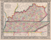
Map of the states of Kentucky and
Tennessee
…
note:
…
Tennessee
is obscured
Johnson's Kentucky and
Tennessee
abstract:
… of Kentucky and
Tennessee
Eastern
Tennessee
, with parts of Alabama
Map of east
Tennessee
& western North
m
Map of Kentucky and
Tennessee
…
abstract:
… for Kentucky and
Tennessee
.
m
Map of Haywood County, Tenn. …
collection:
Map of Haywood County,
Tennessee
m
Map of Maury Co.,
Tennessee
…
Map of the taxing district of…
collection:
Tennessee
Chattanooga : county seat of …
collection:
Tennessee
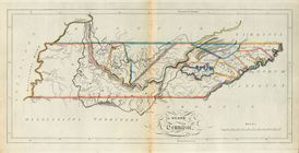
The State of
Tennessee
County map of Kentucky and
Tennessee
…
… and
Tennessee
…
War map of Kentucky
abstract:
… cover most of
Tennessee
Tennessee
Wartburg quadrangle …
m
Map of Madison County, Tenn. …
collection:
Map of Madison County,
Tennessee
Tennessee
Pikeville sheet …
Map of Kentucky and
Tennessee
…
…
Tennessee
…
note:
…, District West
Tennessee
, N
Kentucky
collection:
Tennessee
Map shewing position of 1st B…
note:
… of the
Tennessee
-Georgia boundary
Fourteenth l.h. district
note:
…; on the
Tennessee
River, 255 1/2
Map of the states of Kentucky, and
Tennessee
m
… and
Tennessee
, with parts
m
Map of the city and suburbs o…
collection:
Tennessee
m
… and
Tennessee
, with parts
Sewerage map of the city of M…
collection:
Tennessee
m
Map of Kentucky &
Tennessee
…
Map showing the proposed
Tennessee
, Alabama
m
Kentucky and
Tennessee
…
Map of Nashville,
Tennessee
…
Map of Chattanooga, Tenn.
collection:
Tennessee
Eastern United States, No. 6
abstract:
…,
Tennessee
, Arkansas
Kentucky et
Tennessee
…
Ruiner efter en gammal fastni…
Mineral territory tributary t…
m
Post route map of the states …
collection:
…,
Tennessee
, Kentucky, West
m
Map of Chickamauga & Chattano…
abstract:
… Chattanooga,
Tennessee
County map of Kentucky and
Tennessee
.
m
Post route map of the states …
collection:
…,
Tennessee
, Kentucky, West
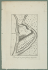
A sketch of the Cherakee boun…
abstract:
… and
Tennessee
meet.
Geological chart of the Unite…
note:
…. Geol. East
Tennessee
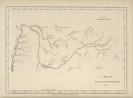
A map of the
Tennessee
Government, 1794.
Map of the state of Kentucky …
Plan of the western seat of w…
note:
General map of Kentucky,
Tennessee
… of
Tennessee
and Georgia
Map of the city of Nashville …
collection:
Tennessee
m
…,
Tennessee
and North Carolina