Click to visit the main New York Public Library Homepage
The New York Public Library
Digital Collections
About Digital Collections
Browse
Search only public domain materials
Items
Collections
Divisions
Home
Search
Browse
About
Search only public domain materials
Items
Collections
Divisions
Digital Collections
Using Images
Using Data
Collections
Charting America: Maps from the Lawrence H. Slaughter Collection and Others
Charting America: Maps from the Lawrence H. Slaughter Collection and Others
Navigation
Filters
Charting America: Maps from the Lawrence H. Slaughter Collection and Others
Previous
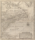
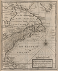
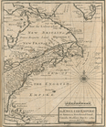
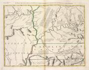
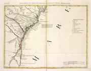
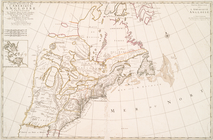
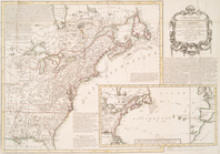
The south part of Virginia, now the north part of Carolina
0
Atlases, gazetteers, guidebooks and other books
377
Maps of the World
16
Maps of the Oceans
24
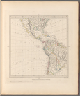
Maps of North and South America
23
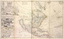
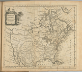
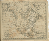
Maps of North America.
551
Maps of New York City and State
1340
Lawrence H. Slaughter Collection of English maps, charts, globes, books and atlases
1020
John H. Levine Collection
60
More
Show filters
Hide filters
Show Only Public Domain
topic
Colonies
17
Geography
6
History
5
Atlases
4
Maps in education
4
More
Less
name
Zatta, Antonio, fl. 1757-1797
12
Moll, Herman, -1732
11
Bowles, John, 1701-1779
6
L'Isle, Guillaume de, 1675-1726
6
Lotter, Matthäus Albrecht, 1741-1810
6
More
Less
collection
x
Lawrence H. Slaughter Collection of English maps, charts, globes, books and atlases
place
x
North America
America
18
Great Britain
18
United States
13
North America -- Maps -- Early works to 1800
12
More
Less
genre
Maps
114
publisher
Presso Antonio Zatta
12
s.n
5
Printed for Timothy Childe at the White Hart at the West-end of St. Paul's Church-yard
4
Chez l'auteur, aux Galeries du Louvre
3
Published by Wm. Faden, geographer to His Majesty, and His R.H. the Prince of Wales
3
More
Less
division
Map Division
113
type
cartographic
113
text
2
Date Range
to
114 results found for:
x
North America?tab=filter
Filtering on:
x
Place
: North America
x
Rights
: Public Domain
x
Collection
: 6a373d50-c5d3-012f-a6fb-58d385a7bc34
Sort by:
Relevance
Title
Date created
Date digitized
Sequence
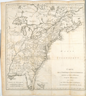
… of the British dominions in
North
America
: from the first
… of the British dominions in
North
America
, according
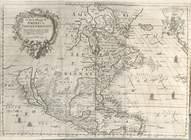
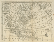
A new mapp of
America
Septentrionale
note:
Tooley. The mapping of
America
, p. 119
North
America
: …
abstract:
Covers continent of
North
America
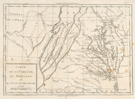
Carte de la Virginie, du Mary…
note:
Research catalog of maps of
America
to 1860
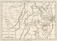
Carte de la Pensylvanie et du…
note:
Research catalog of maps of
America
to 1860
Carte de la Nouvelle York : y…
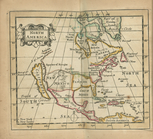
A map of Florida and ye Great…
note:
Covers eastern
North
America
from
North
America
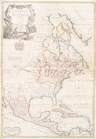
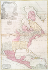
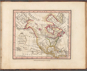
A new map of
North
America
shewing its
collection:
North
America
.
m
North
America
: …
abstract:
… of
North
America
This map of
North
America
, according to ye
m
A new map of the
north
parts of
America
The English empire in
America
, Newfound-land
m
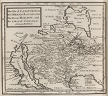
The isle of California, New M…
note:
Covers most of
North
America
, but does
The English Empire in
America
, Newfound-land
note:
Covers eastern
North
America
.
The English empire in
America
, Newfound-land
note:
Covers eastern
North
America
.
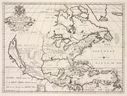
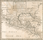
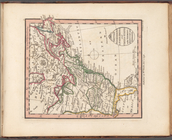
Mexico, or, New Spain : divid…
North
America
, including the West Indies
British possessions in
North
America
and United
Western Coast of
North
America
North
America
from the French of Mr. D'Anville
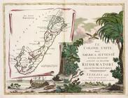
Le colonie unite dell'
America
note:
…'s Storia dell'
America
Il paese de' Selvaggi Outauac…
note:
…'s Storia dell'
America
La parte Occidentale della Nu…
note:
…'s Storia dell'
America
Parte Orientale del Canada, N…
note:
…'s Storia dell'
America
Il paese de' Selvaggi Outagam…
note:
…'s Storia dell'
America
La Pensilvania, la Nuova York…
note:
…'s Storia dell'
America
L'Acadia, le Provincie di Sag…
note:
…'s Storia dell'
America
Il paese de'Cherachesi, con l…
note:
…'s Storia dell'
America
Il Maryland, il Jersey Meridi…
note:
…'s Storia dell'
America
La Giammaica.
note:
…'s Storia dell'
America
Luigiana Inglese, colla parte…
note:
…'s Storia dell'
America
Parte Orientale della Florida…
note:
…'s Storia dell'
America
An accurate map of
North
America
note:
… settlements in
America
Carte d'une partie de l'Améri…
Carte de l'Amérique septentri…
North
America
A map of New England, New Yor…
A new map of
North
America
shewing all
World on gnomonic projection …
Carte nouvelle de l'Amerique …
Carte de la Louisiane et pais…
note:
LC Maps of
North
America
, 1750-1789, 18
… in
America
Septentrionali
note:
LC Maps of
North
America
, 1750-1789, 82
Carte du Canada et de la Loui…
note:
LC Maps of
North
America
, 1750-1789, 72
Carte du Mexique et de la Flo…
note:
Covers
North
America
from the Atlantic
America
Septentrionalis a Domino d'Anville
note:
… of
North
America
, 1750-1789
Carte nouvelle des posséssion…
Dominia Anglorum in
America
Septentrionali
A new map of
North
America
from the latest
note:
LC Maps of
North
America
, 1750-1789, 106