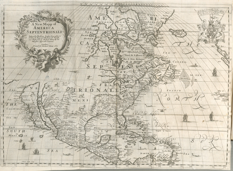
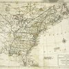
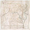
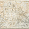
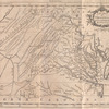
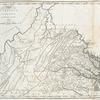
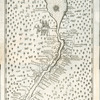
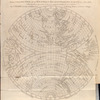
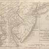
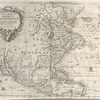
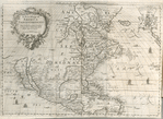
TitleA new mapp of America Septentrionale
NamesBlome, Richard, -1705 (Cartographer)Sanson, Nicolas, 1600-1667 (Cartographer)Lamb, Francis (Engraver)
CollectionLawrence H. Slaughter Collection of English maps, charts, globes, books and atlases
Atlases
A geographical description of the four parts of the world taken from the notes & workes of the famous Monsieur Sanson, geographer to the French king, and other eminent travellers and avthors: To which are added the commodities, coyns, weights, and measures of the chief places of traffick in the world; compared with those of England, (or London) as to the trade thereof. Also, a treatise of travel, and another of traffick ... The whole illustrated with variety of vseful and delightful mapps and figures
Dates / OriginDate Issued: 1670Place: LondonPublisher: Printed by T.N. for R. Blome, and are also sold by N. Brooks, E. Brewster, and T. Basset
Library locationsLionel Pincus and Princess Firyal Map DivisionShelf locator: Map Div. 97-6051 [LHS 327; atlas cases]Shelf locator: Map Div. 97-6051 (Folded map preceding The fourth part) [In LHS 327]
TopicsNorth America
GenresMaps
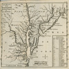
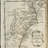
NotesContent: Imprint in cartouche: London : Printed for Richard Blome, 1669.Content: "By His Majesties especiall command."Content: "To the Right Honourable Caecilius Calvert Baron Baltemore ..."Content: Includes decorative cartouche, coat of arms, and ill. of vessels and sea monsters.Content: Lawrence H. Slaughter Collection.Funding: National Endowment for the Humanities Grant for Access to Early Maps of the Middle Atlantic Seaboard.Content: Relief shown pictorially.Content: Shows California as an island.Citation/reference: Tooley. The mapping of America, p. 119Statement of responsibility: designed by Mousieur Sanson, geographer to the French king, and rendred into English and illustrated by Richard Blome ; Francis Lamb, sculp.
Physical DescriptionExtent: 1 map ; 38 x 53 cm., folded to 29 x 19 cm.
Type of ResourceCartographic
IdentifiersNYPL catalog ID (B-number): b14467849RLIN/OCLC: 49399954NYPL catalog ID (B-number): b15369860Universal Unique Identifier (UUID): 74f4ddc0-c5d3-012f-a692-58d385a7bc34
Rights StatementThe New York Public Library believes that this item is in the public domain under the laws of the United States, but did not make a determination as to its copyright status under the copyright laws of other countries. This item may not be in the public domain under the laws of other countries. Though not required, if you want to credit us as the source, please use the following statement, "From The New York Public Library," and provide a link back to the item on our Digital Collections site. Doing so helps us track how our collection is used and helps justify freely releasing even more content in the future.
Item timeline of events
-
-
-
-