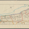
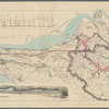
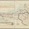
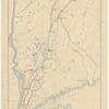
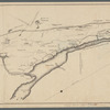
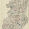
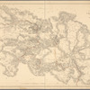
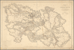
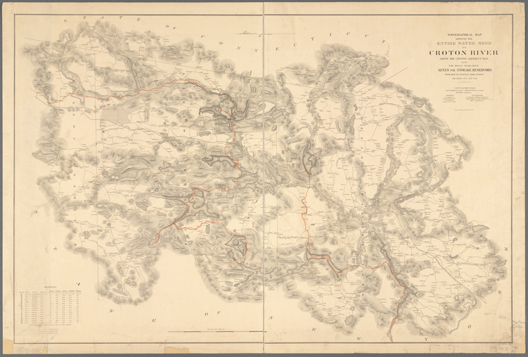
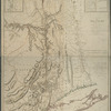
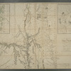
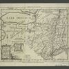
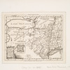
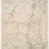
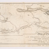
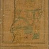
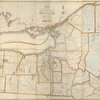
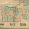
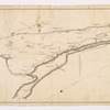
TitleTopographical map showing the entire water shed of Croton River above the Croton Aqueduct Dam: also the most available sites for storage reservoirs : from minute surveys made during the years 1857 and 1858
Additional title: Topographical map showing the entire watershed of Croton River above the Croton Aqueduct DamAdditional title: Entire water shed of Croton River above the Croton Aqueduct DamAdditional title: Croton River above the Croton Aqueduct Dam
NamesNew York (N.Y.). Croton Aqueduct Department (Publisher)Craven, Alfred Wingate, 1810-1879 (Engineer)Morley, James Henry, 1824-1889 (Surveyor)Cushing, G. A. (Surveyor)McMillan, Charles (Draftsman)Bien, Julius, 1826-1909 (Lithographer)
CollectionMaps of New York City and State
Parts
Croton Water System
Dates / OriginDate Issued: 1858 (Inferred)Place: New York N.Y.Publisher: Croton Aqueduct BoardDate Issued: 1858 (Inferred)Place: 24 Vesey St., N.Y.Publisher: Lith of J. Bien
Library locationsLionel Pincus and Princess Firyal Map DivisionShelf locator: Map Div. 16-5904
TopicsRivers -- New York (State) -- Westchester CountyRivers -- New York (State) -- Putnam CountyAqueducts -- New York (State) -- Westchester CountyAqueducts -- New York (State) -- Putnam CountyReservoirs -- New York (State) -- Westchester CountyReservoirs -- New York (State) -- Putnam CountyAqueducts -- New York (State) -- New YorkReservoirs -- New York (State) -- New YorkWater-supply -- New York (State) -- New YorkCroton River Watershed (N.Y.)Croton Aqueduct (N.Y.)New York (State) -- Croton River Watershed
GenresMaps
NotesStatement of responsibility: Croton Aqueduct Board.Content: Relief shown by hachures.Statement of responsibility: "Croton Aqueduct Board: M. van Schaick, Prest. Commissr., Theo. de Forest Asst. Commissr., A.W. Craven chief engineer; engineers: J.H. Morley in charge of survey in 1857, G.A. Cushing in charge of survey in 1858; asst. engineers: D.S. Crosby, Walter S. Church Jr., Thos. A. Emmet Jr., Benj. S. Church, Geo. S. Greene Jr."Statement of responsibility: "Chs. McMillan, Del."Funding: Mapping the Nation (NEH grant, 2015-2018)Version identification: Related version published at a larger scale of approximately 1:36,000.
Physical DescriptionExtent: 1 map ; 63 x 94 cm, on sheet 67 x 99 cm
Type of ResourceCartographic
IdentifiersRLIN/OCLC: 62169080NYPL catalog ID (B-number): b20645731Other local Identifier: US155.1.03Universal Unique Identifier (UUID): efe2cd30-b8ab-0133-9f49-00505686a51c
Rights StatementThe New York Public Library believes that this item is in the public domain under the laws of the United States, but did not make a determination as to its copyright status under the copyright laws of other countries. This item may not be in the public domain under the laws of other countries. Though not required, if you want to credit us as the source, please use the following statement, "From The New York Public Library," and provide a link back to the item on our Digital Collections site. Doing so helps us track how our collection is used and helps justify freely releasing even more content in the future.
Item timeline of events
-
-
-
-


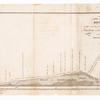
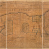
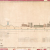
![Plate II. Sketches of villages of the Croton watershed: Westchester County, pt. A [showing sketches of: Bedford Station, Cross River, Katonah, and Mt. Kisco]](https://images.nypl.org/index.php?id=5652833&t=b)
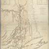
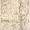
![Plate III : Sketches of villages of the Croton watershed: Westchester County, pt. B [showing sketches of: Somers, Golden's Bridge, Croton Falls, Purdys, South Salem, Salem Center, and North Salem]](https://images.nypl.org/index.php?id=5652834&t=b)
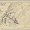
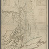
![Plate IV. Sketches of villages of the Croton watershed: Putnam County [showing sketches of: Patterson, Carmel, and Brewster]](https://images.nypl.org/index.php?id=5652835&t=b)