


- The Library Shop
- Privacy Policy
- Rules and Regulations
- Using the Internet
- Website Terms and Conditions
- Gifts of Materials to NYPL
-
© The New York Public Library, 2024
The New York Public Library is a 501(c)(3) | EIN 13-1887440

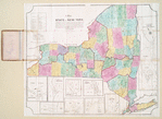
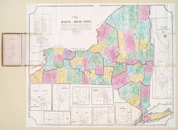
Lionel Pincus and Princess Firyal Map Division, The New York Public Library. "A map of the state of New York : exhibiting the situation and boundaries of the several towns, wards, and counties and specifying in each town, ward, and county, the whole population thereof, and in the several counties, the population upon which the apportionment of senators and members of assembly is based, with tables of apportionment" The New York Public Library Digital Collections. 1845. https://digitalcollections.nypl.org/items/510d47da-efd8-a3d9-e040-e00a18064a99
Lionel Pincus and Princess Firyal Map Division, The New York Public Library. "A map of the state of New York : exhibiting the situation and boundaries of the several towns, wards, and counties and specifying in each town, ward, and county, the whole population thereof, and in the several counties, the population upon which the apportionment of senators and members of assembly is based, with tables of apportionment" New York Public Library Digital Collections. Accessed April 27, 2024. https://digitalcollections.nypl.org/items/510d47da-efd8-a3d9-e040-e00a18064a99
Lionel Pincus and Princess Firyal Map Division, The New York Public Library. (1845). A map of the state of New York : exhibiting the situation and boundaries of the several towns, wards, and counties and specifying in each town, ward, and county, the whole population thereof, and in the several counties, the population upon which the apportionment of senators and members of assembly is based, with tables of apportionment Retrieved from https://digitalcollections.nypl.org/items/510d47da-efd8-a3d9-e040-e00a18064a99
<ref name=NYPL>{{cite web | url=https://digitalcollections.nypl.org/items/510d47da-efd8-a3d9-e040-e00a18064a99 | title=
(cartographic)
A map of the state of New York : exhibiting the situation and boundaries of the several towns, wards, and counties and specifying in each town, ward, and county, the whole population thereof, and in the several counties, the population upon which the apportionment of senators and members of assembly is based, with tables of apportionment, (1845)
|author=Digital Collections, The New York Public Library |accessdate=April 27, 2024 |publisher=The New York Public Library, Astor, Lenox, and Tilden Foundations}}</ref>