


- The Library Shop
- Privacy Policy
- Rules and Regulations
- Using the Internet
- Website Terms and Conditions
- Gifts of Materials to NYPL
-
© The New York Public Library, 2024
The New York Public Library is a 501(c)(3) | EIN 13-1887440
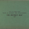
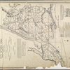
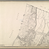
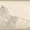
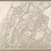
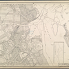
Lionel Pincus and Princess Firyal Map Division, The New York Public Library. "Use district map [1937]" The New York Public Library Digital Collections. 1937. https://digitalcollections.nypl.org/items/32bed860-c605-012f-382b-58d385a7bc34
Lionel Pincus and Princess Firyal Map Division, The New York Public Library. "Use district map [1937]" New York Public Library Digital Collections. Accessed April 26, 2024. https://digitalcollections.nypl.org/items/32bed860-c605-012f-382b-58d385a7bc34
Lionel Pincus and Princess Firyal Map Division, The New York Public Library. (1937). Use district map [1937] Retrieved from https://digitalcollections.nypl.org/items/32bed860-c605-012f-382b-58d385a7bc34
<ref name=NYPL>{{cite web | url=https://digitalcollections.nypl.org/items/32bed860-c605-012f-382b-58d385a7bc34 | title=
(cartographic)
Use district map [1937], (1937)
|author=Digital Collections, The New York Public Library |accessdate=April 26, 2024 |publisher=The New York Public Library, Astor, Lenox, and Tilden Foundations}}</ref>
![Use district map [1937]](https://s3.amazonaws.com/repo-transcoded-web-media-thumnails/3319fb80-c605-012f-d283-58d385a7bc34/3319fb80-c605-012f-d283-58d385a7bc34-00002.jpg)