


![Central Park : memorial of the Common Council of the City of New York to the Legislature, approved June 11th, 1853...[title page]](https://images.nypl.org/index.php?id=5190254&t=b)


- The Library Shop
- Privacy Policy
- Rules and Regulations
- Using the Internet
- Website Terms and Conditions
- Gifts of Materials to NYPL
-
© The New York Public Library, 2024
The New York Public Library is a 501(c)(3) | EIN 13-1887440

Lionel Pincus and Princess Firyal Map Division, The New York Public Library. "Guide map to 92 acres of land at Washington Heights in the 12th ward of the City of New York to be sold by the executors of Isaac Dyckman Dec'd, on the 1st day of June 1870 at the Exchange salesroom, no. 111 Broadway : showing its situation with reference to all that part of the City of New York north of the Central Park, and also showing the new Streets and Avenues established by the Commissioners of the Central Park." The New York Public Library Digital Collections. 1870. https://digitalcollections.nypl.org/items/44e428e0-f3a2-0130-9e6c-58d385a7b928
Lionel Pincus and Princess Firyal Map Division, The New York Public Library. "Guide map to 92 acres of land at Washington Heights in the 12th ward of the City of New York to be sold by the executors of Isaac Dyckman Dec'd, on the 1st day of June 1870 at the Exchange salesroom, no. 111 Broadway : showing its situation with reference to all that part of the City of New York north of the Central Park, and also showing the new Streets and Avenues established by the Commissioners of the Central Park." New York Public Library Digital Collections. Accessed May 14, 2024. https://digitalcollections.nypl.org/items/44e428e0-f3a2-0130-9e6c-58d385a7b928
Lionel Pincus and Princess Firyal Map Division, The New York Public Library. (1870). Guide map to 92 acres of land at Washington Heights in the 12th ward of the City of New York to be sold by the executors of Isaac Dyckman Dec'd, on the 1st day of June 1870 at the Exchange salesroom, no. 111 Broadway : showing its situation with reference to all that part of the City of New York north of the Central Park, and also showing the new Streets and Avenues established by the Commissioners of the Central Park. Retrieved from https://digitalcollections.nypl.org/items/44e428e0-f3a2-0130-9e6c-58d385a7b928
<ref name=NYPL>{{cite web | url=https://digitalcollections.nypl.org/items/44e428e0-f3a2-0130-9e6c-58d385a7b928 | title=
(cartographic)
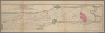
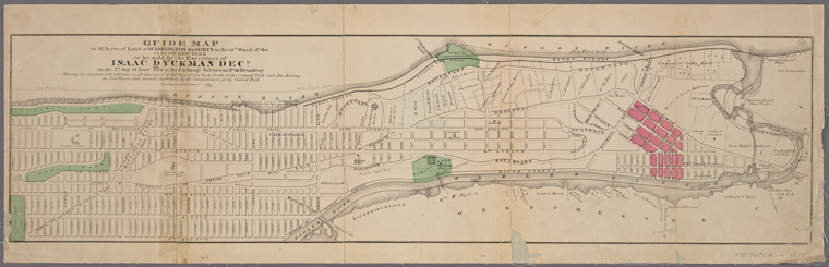
Guide map to 92 acres of land at Washington Heights in the 12th ward of the City of New York to be sold by the executors of Isaac Dyckman Dec'd, on the 1st day of June 1870 at the Exchange salesroom, no. 111 Broadway : showing its situation with reference to all that part of the City of New York north of the Central Park, and also showing the new Streets and Avenues established by the Commissioners of the Central Park., (1870)
|author=Digital Collections, The New York Public Library |accessdate=May 14, 2024 |publisher=The New York Public Library, Astor, Lenox, and Tilden Foundations}}</ref>