


![Travels in South America.... [Title page]](https://images.nypl.org/index.php?id=1131292&t=b)
![Travels in South America.... [Title page]](https://images.nypl.org/index.php?id=1131299&t=b)
- The Library Shop
- Privacy Policy
- Rules and Regulations
- Using the Internet
- Website Terms and Conditions
- Gifts of Materials to NYPL
-
© The New York Public Library, 2024
The New York Public Library is a 501(c)(3) | EIN 13-1887440
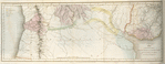
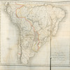
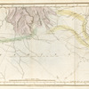
General Research Division, The New York Public Library. "Map of the country between Buenos Ayres and the Pacific Ocean with a specification of the different geological formations." The New York Public Library Digital Collections. 1825. https://digitalcollections.nypl.org/items/510d47dd-d984-a3d9-e040-e00a18064a99
General Research Division, The New York Public Library. "Map of the country between Buenos Ayres and the Pacific Ocean with a specification of the different geological formations." New York Public Library Digital Collections. Accessed April 30, 2024. https://digitalcollections.nypl.org/items/510d47dd-d984-a3d9-e040-e00a18064a99
General Research Division, The New York Public Library. (1825). Map of the country between Buenos Ayres and the Pacific Ocean with a specification of the different geological formations. Retrieved from https://digitalcollections.nypl.org/items/510d47dd-d984-a3d9-e040-e00a18064a99
<ref name=NYPL>{{cite web | url=https://digitalcollections.nypl.org/items/510d47dd-d984-a3d9-e040-e00a18064a99 | title=
(cartographic)
Map of the country between Buenos Ayres and the Pacific Ocean with a specification of the different geological formations., (1825)
|author=Digital Collections, The New York Public Library |accessdate=April 30, 2024 |publisher=The New York Public Library, Astor, Lenox, and Tilden Foundations}}</ref>