


- The Library Shop
- Privacy Policy
- Rules and Regulations
- Using the Internet
- Website Terms and Conditions
- Gifts of Materials to NYPL
-
© The New York Public Library, 2024
The New York Public Library is a 501(c)(3) | EIN 13-1887440
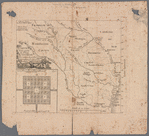
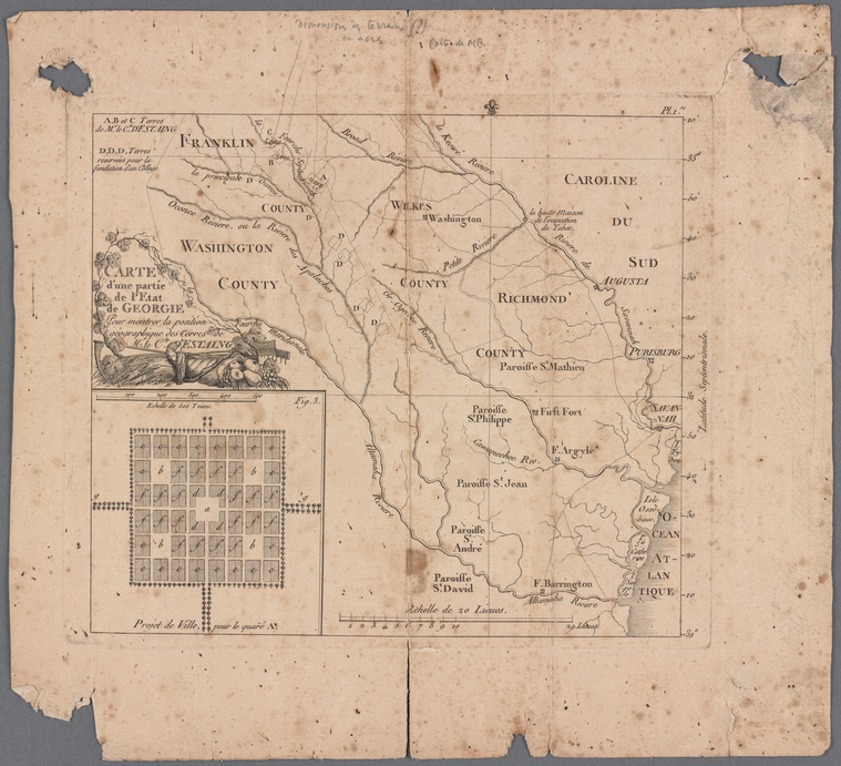
Manuscripts and Archives Division, The New York Public Library. "Carte d'une partie de l'Etat de Georgie" The New York Public Library Digital Collections. 1796 - 1815. https://digitalcollections.nypl.org/items/aef9fca0-f418-0132-e5c7-58d385a7b928
Manuscripts and Archives Division, The New York Public Library. "Carte d'une partie de l'Etat de Georgie" New York Public Library Digital Collections. Accessed May 1, 2024. https://digitalcollections.nypl.org/items/aef9fca0-f418-0132-e5c7-58d385a7b928
Manuscripts and Archives Division, The New York Public Library. (1796 - 1815). Carte d'une partie de l'Etat de Georgie Retrieved from https://digitalcollections.nypl.org/items/aef9fca0-f418-0132-e5c7-58d385a7b928
<ref name=NYPL>{{cite web | url=https://digitalcollections.nypl.org/items/aef9fca0-f418-0132-e5c7-58d385a7b928 | title=
(cartographic)
Carte d'une partie de l'Etat de Georgie, (1796 - 1815)|author=Digital Collections, The New York Public Library |accessdate=May  1, 2024 |publisher=The New York Public Library, Astor, Lenox, and Tilden Foundations}}</ref>