Click to visit the main New York Public Library Homepage
The New York Public Library
Digital Collections
About Digital Collections
Browse
Search only public domain materials
Items
Collections
Divisions
Home
Search
Browse
About
Search only public domain materials
Items
Collections
Divisions
Digital Collections
Using Images
Using Data
Search
Filtered search
Show filters
Hide filters
Show Only Public Domain
topic
Real property
1906
Administrative and political divisions
495
Railroads
367
Fire insurance
350
Landowners
350
More
Less
name
Beers, F. W. (Frederick W.)
290
Sanborn Map Company
289
G.M. Hopkins & Co
220
Burr, David H., 1803-1875
165
New York (N.Y.). City Planning Commission
164
More
Less
collection
Atlases of the United States
2114
Maps of New York City and State
1306
Atlases of New York City
1156
Maps of North America
939
Lawrence H. Slaughter Collection of English maps, charts, globes, books and atlases
299
More
Less
place
New York (State)
2754
New York (N.Y.)
924
New York
853
New Jersey
422
Manhattan (New York, N.Y.)
382
More
Less
genre
Maps
5729
Atlases
2097
Cadastral maps
294
Title pages
113
Topographic maps
66
More
Less
publisher
Sanborn Map Company
277
E. Belcher Hyde
181
MIT Press
163
publisher not identified
151
G.W. Bromley & Co
145
More
Less
division
x
Map Division
type
cartographic
5583
text
284
still image
225
Date Range
to
5,961 results found
Filtering on:
x
Division
: Map Division
x
Title
: "Classified Business Directory of Erie County, New York (City of Buffalo)"
Sort by:
Title
Date created
Date digitized
Sequence
m
Map of the Cedar Knolls, at B…
Plan of the Central Park, Cit…
Schuylerville Business Direct…
References; Waterford [Villag…
Beechers Hollow [Village]; Be…
Map of Saratoga County
New topographical atlas of Sa…
Acres of Land, Population, Dw…
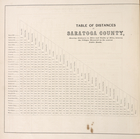
Table of Distances in Saratog…
Ballston Spa Business Directo…
Grangerville [Village]; Grang…
Corinth [Township]; Palmer Fa…
Clifton Park [Village]; Clift…
Day Corners Business Director…
Crescent [Village]; Crescent …
Galway [Township]; Yorks Corn…
Greenfield [Township]; Pages …
Bloodville [Village]; Bloodvi…
Hadley [Township]; Hadley Bus…
Factory Village [Village]; Fa…
Burnt Hills [Village]; Burnt …
Conklingville [Village]; Conk…
Providence [Township]; Hagedo…
References; Saratoga Springs …
Map of the borough of Brookly…
Records of searches in relati…
Map of the borough of Brookly…
Hammond's handy reference map…
m
Map of the borough of Brookly…
Hammond's complete map of New…
Map of New York City and vici…
m
The Blanchard Press correctly…
Educational extension work of…
Map of the comprehensive plan…
Rand, McNally & Co.'s new aut…
Map and profile showing sourc…
The Evening Mail's complete m…
Tracts and farms with street …
m
The John Wanamaker automobile…
New York and vicinity roads a…
m
Official map covering territo…
Map of Jamaica in the 4th war…
Rail terminal facilities in G…
m
Rand, McNally & Co.'s complet…
Railroads in Manhattan, Jerse…
Map of the suburban territory…
Road map of the New York dist…
Map of property New York Dock…
Brooklyn, from Rand McNally m…
m
New York City and vicinity
1
2
3
4
5
6
7
8
9
10
…
23
24
Previous
Next
1
2
3
4
5
6
7
8
9
10
…
23
24
Previous
Next