Click to visit the main New York Public Library Homepage
The New York Public Library
Digital Collections
About Digital Collections
Browse
Search only public domain materials
Items
Collections
Divisions
Home
Search
Browse
About
Search only public domain materials
Items
Collections
Divisions
Digital Collections
Using Images
Using Data
Search
Filtered keyword search
Show filters
Hide filters
Show Only Public Domain
name
Bell, A. (Andrew), 1728-1779
1
Wyld, James, 1812-1887
1
collection
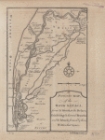
A particular map of the River Sanaga, from its mouth to the desart, exhibiting its several branches, and the islands formed by them within that space
1
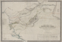
Map of part of the western coast of Africa extending from the Isles de Loss to Sherboro Island, particularly exhibiting the discoveries lately made to the N.E. of Sierra Leone by Surgeon O'Beirne and Major Laing
1
Map of the Old Continent exhibiting its greatest diametrical length from the point of East Tartary to the Cape of Good Hope
1
place
Africa
1
Asia
1
Early works 1800
1
Europe
1
Maps
1
More
Less
genre
x
Maps
publisher
s.n
2
J. Wyld
1
division
x
Schomburg Jean Blackwell Hutson Research and Reference Division
type
cartographic
3
Date Range
to
3 results found for:
x
International Health Exhibition (1884 : London, England)
Filtering on:
x
Division
: Schomburg Jean Blackwell Hutson Research and Reference Division
x
Genre
: Maps
Sort by:
Relevance
Title
Date created
Date digitized
Sequence
Map of the Old Continent
exhibiting
its
use:
Can be used inside free NYPL
exhibition
…,
exhibiting
its several
use:
Can be used inside free NYPL
exhibition
…, particularly
exhibiting
use:
Can be used inside free NYPL
exhibition