Click to visit the main New York Public Library Homepage
The New York Public Library
Digital Collections
About Digital Collections
Browse
Search only public domain materials
Items
Collections
Divisions
Home
Search
Browse
About
Search only public domain materials
Items
Collections
Divisions
Digital Collections
Using Images
Using Data
Search
Filtered keyword search
Show filters
Hide filters
Show Only Public Domain
topic
Nautical charts
14
Administrative and political divisions
5
Harbors
4
Railroads
4
Canals
3
More
Less
name
Blunt, Edmund M. (Edmund March), 1770-1862
5
Fisher, Joshua, 1707-1783
5
Ferguson, James, 1710-1776
4
Gedney, Thomas R
4
Hassler, F. R. (Ferdinand Rudolph), 1770-1843
4
More
Less
collection
Maps of North America
12
Lawrence H. Slaughter Collection of English maps, charts, globes, books and atlases
9
Maps of New York City and State
7
Atlases of the United States
3
Cartographic materials from the Emmet collection of manuscripts etc. relating to American history
1
place
x
New Jersey
New York (N.Y.)
10
Delaware
9
Delaware Bay (Del. and N.J.)
7
New York Harbor (N.Y. and N.J.)
6
More
Less
genre
x
Maps
Atlases
3
Geological maps
2
Early works to 1800
1
Facsimiles
1
publisher
Pub. by E.M. Blunt for W. Hooker
3
Survey of the Coast of the United States
3
Geological Survey of New Jersey
2
Published ... by Andrew Dury, Duke's Court, St. Martins Lane
2
... Wm. Faden ...
1
More
Less
division
Map Division
32
type
cartographic
32
Date Range
to
32 results found for:
x
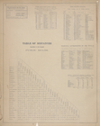
Tables
Filtering on:
x
Genre
: Maps
x
Place
: New Jersey
Sort by:
Relevance
Title
Date created
Date digitized
Sequence
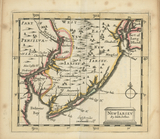
New Iarsey
collection:
… : with geographical
tables
, explaining
m
Topographical map of Union Co…
note:
… landscape views, and
tables
m
Post route map of the states …
note:
Includes notes and
tables
: Explanation
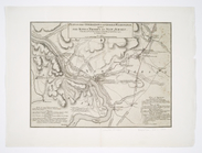
Plan of the operations of Gen…
note:
Includes notes and
tables
, "Loss
A general map of the middle B…
note:
Includes historical notes, 3 distance
tables
An actual survey of the sea c…
Map of the mines, canals, and…
note:
… p. :
tables
; 21 cm.
… and Distance
Table
A chart of Delaware Bay and R…
note:
Includes tide-
table
and list of pilots
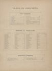
Table
of Contents.
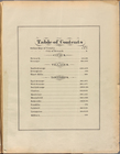
Table
of Contents
A chart of Delaware Bay and R…
note:
Includes tide-
table
and list of pilots
Topographical map of the stat…
note:
Includes a
table
of census of New Jersey.
Map of the vicinity of Hibern…
note:
…"Topography from the original plane-
table
sheets
Map of the rail-roads of the …
note:
Includes a vignette and
table
of "Length of rail
A new county map of the state…
note:
Statistical
table
shows population
Engineers map of the state of…
note:
Includes a vignette and
table
of "Length of rail
A chart of Delaware Bay and R…
note:
Includes list of subscribers and "Tide
table
."…
A chart of Delaware Bay and R…
note:
Includes list of subscribers and "Tide
table
."…
A chart of Delaware Bay and R…
note:
Includes text and "Tide
table
."…
Baye de la Delaware avec les …
note:
Includes inset of Philadelphia, "
Table
des marhes
m
Map showing the survey of lan…
note:
Includes
table
of distances.
The Province of New Jersey : …
note:
Includes
table
of "Astronomical observations."…
m
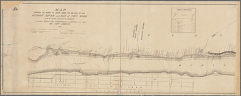
Map of New-York Bay and Harbo…
note:
Includes text,
table
of currents, notes
m
New map of Burlington County:…
note:
…
table
, and 5 vignettes
Triassic formation: including…
note:
Includes a
table
of colors and 6 sections.
Entrance to New York Bay from…
collection:
…. Together with a tide
table
Nautical chart of Little Egg …
collection:
…. Together with a tide
table
The Bay and river of Delaware
collection:
…. Together with a tide
table
m
Map of New-York Bay and Harbo…
note:
Includes text,
table
of currents, notes
Map of New-York Bay and Harbo…
note:
Includes text,
table
of currents, and 4
Map of New-York Bay and Harbo…
note:
Includes text,
table
of currents, and 4
End of results
|
Top