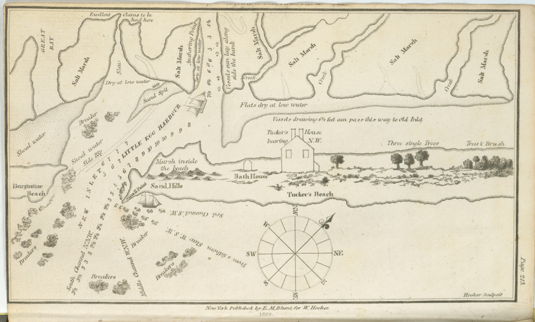
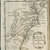
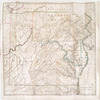
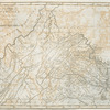
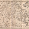
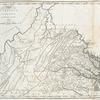
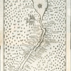
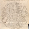
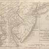
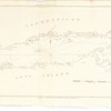
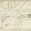
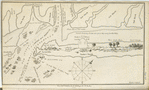
TitleNautical chart of Little Egg Harbour, New Jersey
NamesHooker, William (Engraver)Blunt, Edmund M. (Edmund March), 1770-1862 (Publisher)
CollectionLawrence H. Slaughter Collection of English maps, charts, globes, books and atlases
Atlases
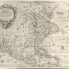
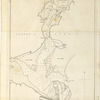
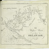
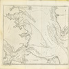
The American coast pilot; containing the courses and distances between the principal harbours, capes, and headlands, on the coast of North and South America; with directions for sailing into the same ... with the prevailing winds, setting of the currents, &c., and the latitudes and longitudes of the principal harbours and capes. Together with a tide table. By Edmund M. Blunt. Cor. and improved by information derived from official documents, actual observations, and the most experienced pilots.
Dates / OriginDate Issued: 1822Place: New-YorkPublisher: Pub. by E.M. Blunt for W. Hooker
Library locationsLionel Pincus and Princess Firyal Map DivisionShelf locator: Map Div. 97-6448[LHS 4003, atlas cases]Shelf locator: Map Div. 97-6448 (Map facing p. 213) [In LHS 4003]
TopicsBlunt, G. W. (George William), 1802-1878Nautical chartsPilot guides -- Atlantic Coast (North America)Pilot guides -- Atlantic Coast (South America)New JerseyNautical charts -- New Jersey -- Little Egg Harbor (N.J. : Township)
GenresMaps
NotesContent: 10th ed.Content: Copy in Map Div. 97-6448 in Lawrence H. Slaughter Collection.Content: Copy in Map Div. 97-6448 includes appended advertisements, [7] p., beginning with "Chart and quadrant store, George W. Blunt," listing available charts.Content: Lawrence H. Slaughter Collection ; 4003.Content: National Endowment for the Humanities Grant for Access to Early Maps of the Middle Atlantic Seaboard.Content: "Page 213."Content: Relief shown pictorially. Depths shown by soundings.Content: "Engraved for The American coast pilot."Content: Includes ill.Content: Lawrence H. Slaughter Collection.Content: NYPL copy trimmed along upper margin; some text trimmed off.Content: Oriented with north toward the upper right.Content: Title given by the cataloger.Statement of responsibility: Hooker sculpsit.
Physical DescriptionExtent: 1 map ; 12 x 21 cm.
Type of ResourceCartographic
IdentifiersRLIN/OCLC: 6340079NYPL catalog ID (B-number): b12990398RLIN/OCLC: 48959354NYPL catalog ID (B-number): b15337570Universal Unique Identifier (UUID): cb28a870-c5d4-012f-88e0-58d385a7bc34
Rights StatementThe New York Public Library believes that this item is in the public domain under the laws of the United States, but did not make a determination as to its copyright status under the copyright laws of other countries. This item may not be in the public domain under the laws of other countries. Though not required, if you want to credit us as the source, please use the following statement, "From The New York Public Library," and provide a link back to the item on our Digital Collections site. Doing so helps us track how our collection is used and helps justify freely releasing even more content in the future.
Item timeline of events
-
-
-
-