Click to visit the main New York Public Library Homepage
The New York Public Library
Digital Collections
About Digital Collections
Browse
Search only public domain materials
Items
Collections
Divisions
Home
Search
Browse
About
Search only public domain materials
Items
Collections
Divisions
Digital Collections
Using Images
Using Data
Search
Filtered keyword search
Show filters
Hide filters
Show Only Public Domain
topic
Elevated railroads
1
Historical geography
1
Homes and haunts
1
Landowners
1
Middle Atlantic States
1
More
Less
name
Randel, John
3
Maverick, Peter, 1780-1831
2
Bridges, William, -1814
1
Dripps, M. (Matthew)
1
E. Robinson Co
1
More
Less
collection
Atlases of New York City
28
I. N. Phelps Stokes Collection of American Historical Prints
2
Maps of New York City and State
2
Commissioners' plan of Manhattan Island and report with related materials
1
The Eno collection of New York City views
1
place
New York (N.Y.)
3
New York (State)
3
Manhattan (New York, N.Y.)
2
New York
2
Broadway (New York, N.Y.)
1
More
Less
genre
Maps
32
Prints
3
Title pages
1
publisher
David T. Valentine
1
E. Robinson Co
1
John Randel Junr
1
M. Dripps
1
division
Map Division
30
Wallach Division: Print Collection
3
Manuscripts and Archives Division
1
type
cartographic
32
still image
1
text
1
Date Range
to
34 results found for:
x
Randel, John
Filtering on:
x
Rights
: Public Domain
Sort by:
Relevance
Title
Date created
Date digitized
Sequence
A map of the states of Connec…
note:
…, by their secretary and surveyor
John
m
Plan of Manhattan Island
collection:
Randel
map of 1811
This map of the city of New Y…
note:
… Bridges but by
John
Randel
…. Valentine, C.C., by
John
…
collection:
…. Valentine, C.C., by
John
Randel
, Junr. C.E.
Plate 45: Map No. 20 [Bounded…
note:
… by
John
Randel
, Jr.
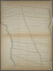
Bounded by W. 19th Street, Se…
note:
laid out by
John
Randel
, jr., 1819-20
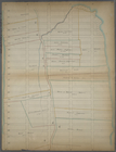
Bounded by E. Twenty First St…
note:
laid out by
John
Randel
, jr., 1819-20
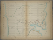
Bounded by (Chelsea), W. 36th…
note:
laid out by
John
Randel
, jr., 1819-20
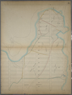
Bounded by W. 57th Street, Ei…
note:
laid out by
John
Randel
, jr., 1819-20
Bounded by E. 94th Street, Ea…
note:
laid out by
John
Randel
, jr., 1819-20
Bounded by W. 94th Street, Ei…
note:
laid out by
John
Randel
, jr., 1819-20
Bounded by E. 115th Street (S…
note:
laid out by
John
Randel
, jr., 1819-20
Bounded by W. 135th Street, E…
note:
laid out by
John
Randel
, jr., 1819-20
Bounded by W. 131st Street, H…
note:
laid out by
John
Randel
, jr., 1819-20
Bounded by W. 156th Street, (…
note:
laid out by
John
Randel
, jr., 1819-20
Bounded by W. 155th Street, H…
note:
laid out by
John
Randel
, jr., 1819-20
Bounded by W. 177th Street, H…
note:
laid out by
John
Randel
, jr., 1819-20
Bounded by 199th Street, Harl…
note:
laid out by
John
Randel
, jr., 1819-20
Bounded by W. 211th Street, H…
note:
laid out by
John
Randel
, jr., 1819-20
Bounded by W. 228th Street, H…
note:
laid out by
John
Randel
, jr., 1819-20
Bounded by Abingdon Road, Lov…
note:
laid out by
John
Randel
, jr., 1819-20
Bounded by Luise Street (Kips…
note:
laid out by
John
Randel
, jr., 1819-20
Bounded by W. 52nd Street, (M…
note:
laid out by
John
Randel
, jr., 1819-20
Bounded by Fifth Avenue, 52nd…
note:
laid out by
John
Randel
, jr., 1819-20
Bounded by W. 77th Street, (C…
note:
laid out by
John
Randel
, jr., 1819-20
Bounded by W. 73rd Street, E.…
note:
laid out by
John
Randel
, jr., 1819-20
Bounded by E. 72nd Street (Up…
note:
laid out by
John
Randel
, jr., 1819-20
PBounded by W. 93rd Street (Y…
note:
laid out by
John
Randel
, jr., 1819-20
Bounded by W. 115th Street (M…
note:
laid out by
John
Randel
, jr., 1819-20
Bounded by W. 114th Street, F…
note:
laid out by
John
Randel
, jr., 1819-20
Bounded by W. 135th Street, E…
note:
laid out by
John
Randel
, jr., 1819-20
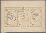
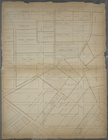
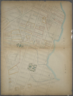
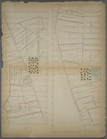
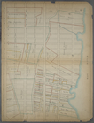
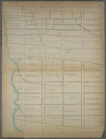
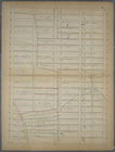
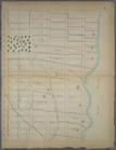
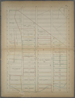
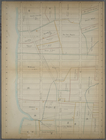
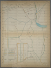
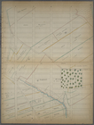
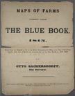
Maps of farms commonly called…
note:
laid out by
John
Randel
, jr., 1819-20
… invented by
John
Randel
m
Topographical map of New York…
note:
based on
Randells
and other official surveys
End of results
|
Top