This collection is also available in Archives & Manuscripts
View In Archives »
Collection Data
- Description
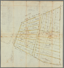
- Gerard Bancker (1740-1799) and brother Evert Bancker Jr. (1734-1815) were New York City surveyors and members of a wealthy merchant family. The land surveys, plats, and maps that comprise the bulk of the Bancker plans depict the streets, buildings, farms, and riverbanks of early New York. They were commissioned by individuals, churches, proprietors, and city government (The Corporation of the City of New York) and were created between 1667 and 1821, with the bulk of the collection dating from 1770 to 1810. There are also some surveys of land in upstate New York, New Jersey, Pennsylvania, and Vermont.
- Names
- Bancker, Evert, 1734-1815 (Creator)
- Bancker, Gerard, 1740-1799 (Creator)
- Maerschalk, Francis (Creator)
- Dates / Origin
- Date Created: 1667 - 1821
- Library locations
- Manuscripts and Archives Division
- Shelf locator: MssCol 193
- Topics
- African Burial Ground -- New York (N.Y.)
- Real property -- New Jersey
- Real property -- New York (State)
- Real property -- New York (State) -- New York
- Real property -- Pennsylvania
- Surveying -- New York (State)
- New York (N.Y.)
- Westchester County (N.Y.)
- Surveyors
- Genres
- Surveys
- Maps
- Plats
- Documents
- Manuscripts
- Notes
- Biographical/historical: Gerard Bancker (1740-1799) and brother Evert Bancker Jr. (1734-1815) were New York City surveyors and members of a wealthy merchant family. They worked both in an official capacity as county and city surveyors, and for private land owners. Gerard was the first treasurer of the State of New York, an office he held from 1778 to 1798. He was also appointed one of the commissioners for determining and settling the New York-Massachusetts boundary in 1773, and again in 1783. Evert Bancker Jr. was a merchant and loyalist who lived in New York City. He was involved in land conveyance and the settling of estates. The Banckers worked with other surveyors, such as Francis Maerschalk, in creating some of their surveys.
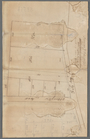
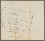
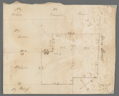
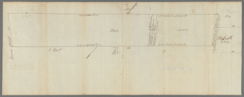
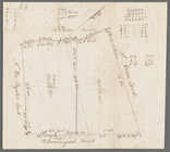
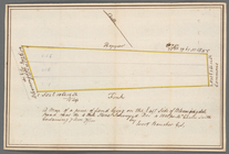
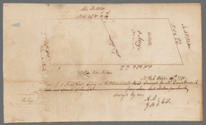
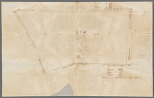
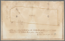
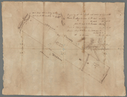
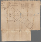
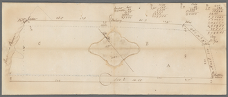
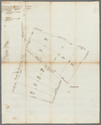
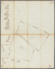
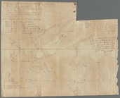
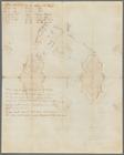
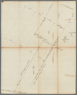
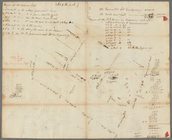
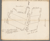
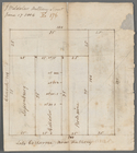
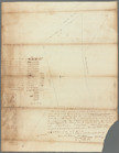
- Content: The surveys, plats, and maps that comprise the bulk of the Bancker plans show the streets, buildings, farms, and harbors of early New York. They were commissioned by individuals, churches, proprietors, and city government (The Corporation of the City of New York) and were created between 1667 and 1821, with the bulk of the collection dating from 1770 to 1810. They reflect a period of rapid population growth when the large estates and farms that constituted much of New York and Brooklyn were being broken up into lots to be sold or rented. A concentration of the plans are from just before, during, and after the Revolutionary period and continue into the Early National era. The majority of the surveys describe lower Manhattan, but also include the less developed farms and estates of upper Manhattan, Brooklyn, Queens, Westchester, and Staten Island. There are also some surveys of land in upper New York State, New Jersey, Pennsylvania, and Vermont; and surveys and related material for land adjacent to the Susquehanna River.
The surveys show comprehensive details of land prepared for inheritors of estates; to resolve boundary disputes; for use in deeds and inheritance proceedings; or for proposed works, such as new roads, buildings, drains, and wharves. Most of the surveys appear to be drafts, sketches, or working documents and some are copies or reworking of other surveyors' work, such as those of Francis Maerschalk and C. T. Goerck. A number of plats record the division and conveyance of lots of land under water (or "soil under water") extending into the Hudson and East River, an activity especially prevalent in the late 18th century.
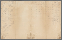
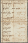
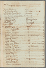
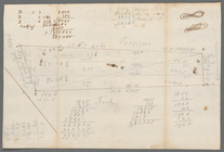
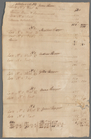
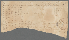
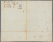
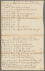
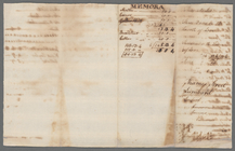
The collection contains a detailed journal of a surveying trip along the Susquehanna River via Staten Island in 1789. A booklet of hand-drawn maps of counties in the Central New York Military tract includes land tracts, water courses, and other geological features. The memoranda, lists, notes, and computations in the collection are mostly by Evert Bancker Jr., and include details of proprietors and tenants; and the measurements and value of various parcels of land.
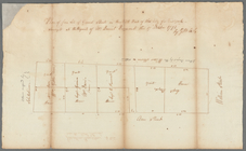
Buildings and Lot Summaries contains a methodical description of lots south of Wall Street. These describe the construction of houses and their interiors and furnishings; other buildings such as stores, stables, and outhouses and their condition; cisterns and ash pits; and details as to dimensions and owners.
The collection notably contains surveys and documents from land on and contiguous with the African Burial Ground in lower Manhattan. These items can be found in box 2, folder 34 to folder 44. See also box 11, folder 40 and 41. The plans in box 3, folders 41 to 43, box 4, folder 62, and box 11, folder 60, may also yield further relevant information.
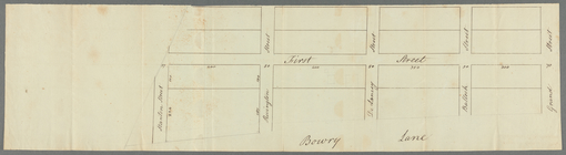
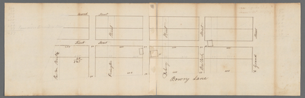
A plan from 1796 depicts a block of land broken into plots near Bowery Lane with the names of the previous owners, most likely manumitted men who had been enslaved by the Dutch West India Company (box 1, folders 46 and 47).
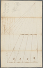
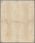
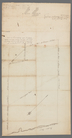
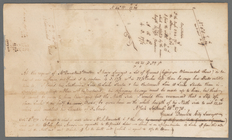
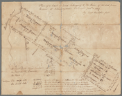
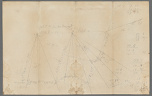
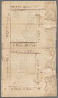
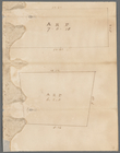
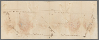
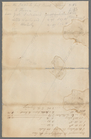
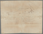
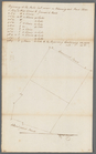
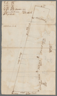
The surveyors used the "metes and bounds" method. This generally includes three elements: directions and distances of survey lines; a narrative description of physical features of the local geography, such as rocks and trees; and the names of owners of adjacent properties. Some plans include only the narrative component. Measurements are mostly in chains and rods (or perches), and Dutch or English feet. The collection also includes to-scale plats showing boundaries and divisions. Many draft plans show the surveyor's workings in calculating acreage and boundary measurements. Some plans depict details of natural and built features of the land such as topography, buildings, gates, and fences.
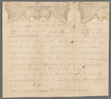
Titles of surveys are taken from the documents or devised in the case where no title was given. Titles have been changed or shortened for clarity in some instances. Names appearing with the title of the survey have been transcribed, followed by the streets and estates that border the plots depicted. Names included in the record may be the commissioners of the survey, current or previous proprietors, heirs of estates, tenants, individuals involved in boundary disputes, or names commonly associated with a piece of land, such as "Lispenard's meadow." Some items show multiple surveys, or original surveys annotated at a later date.
The surveyors frequently used different variations of spelling for names and places. When searching the finding aid, it could be useful to try variants such as De Lancey for Delancey, and Rapelie for Rapelje, and Van Courtland or Cortland for Van Cortlandt.
The received arrangement is largely maintained. The bulk of the items are in loose alphabetical order by prominent street names, or geographical area. Surveys in the Estates grouping are organized by the name of the estate owner, or commissioner of the survey. There has been an attempt to keep maps of adjacent areas or streets together.
- Physical Description
- Extent: 3.31 linear feet 15 boxes, 2 oversized folders
- Type of Resource
- Text
- Cartographic
- Identifiers
- NYPL catalog ID (B-number): b21158621
- MSS Unit ID: 193
- Universal Unique Identifier (UUID): 0a16ae00-c473-0134-a669-00505686d14e