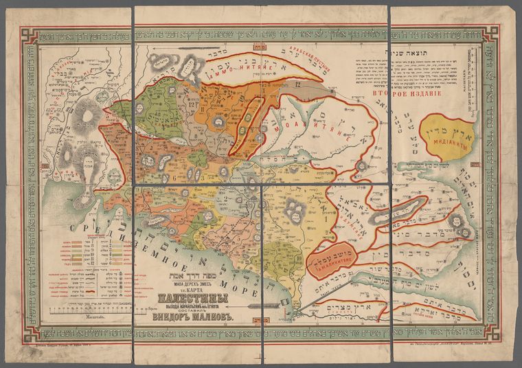
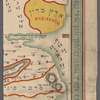
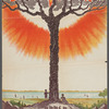
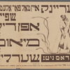
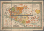
TitleMapah derekh emet : Mapa Derekhʺ emesʺ : t.e. Karta Palestiny idorogi vykhoda Izrailʹīi︠a︡nʺ izʺ Egipta
Additional title: Mapa Derekhʺ emesʺ Additional title: Karta Palestiny i pravednoĭ dorogi vykhoda Izraelʹīti︠a︡nʺ iz EgiptaAdditional title: מפה דרך אמת Additional title: Мапа дерехъ емесъ Additional title: Карта Палестины и праведной дороги выхода Израильіянъ изъ Египта
NamesMalḳoṿ, Avigdor ben Mordekhai (Creator)מלקוב, אביגדור בן מרדכי (Creator)
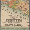
Dates / OriginEdition: Vtoroe izdanīe.Date Issued: 1899Place: VarshavaPublisher: Tipo-Litografīi "Konkordīi︠a︡,
Library locationsDorot Jewish DivisionShelf locator: **P 23-13
TopicsBible -- GeographyExodus, ThePalestine -- Boundaries
GenresPrintsMaps
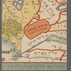
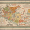
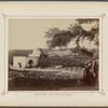
NotesContent: "Dozboleno t︠s︡enzuri︠u︡ Varshava, 28 Apri︠e︡li︠a︡ 1899 g."Content: Horizontal scale, which covers lands of the Twelve tribes of Israel from Canaan to the Transjordan, approximated from horizontal bar scale given in versts. Vertical scale, which covers territory of Moabites and Ammonites, approximated from vertical bar scale given in versts.Content: No prime meridians indicated. Coordinates innacurate on map; approximated from online bounding box tool.Content: Includes key with explanation of colors.Content: Relief shown by by hachures.Content: Shows provinces of the Twelve tribes of Israel, cities of refuge, small towns and villages, principal and secondary roads, and railway lines.Content: Scale ca.: 1: 700,219. Vertical scale ca. 1: 3,693,462 (E 32°19'00"--E 44°28'00"/N 34°29'00"--N 27°42'00")Statement of responsibility: составилъ Викдоръ Малковъ
Physical DescriptionChromolithographsExtent: 1 map : color lithograph ; 595 x 850 cm, folded in cover 29 x 23 cm
Type of ResourceCartographic
LanguagesHebrewRussian
IdentifiersRLIN/OCLC: 1407119163NYPL catalog ID (B-number): b23178445NYPL Exhibition ID: TL 24.01.088Universal Unique Identifier (UUID): 439d35a0-6aae-013c-6680-0242ac110003
Rights StatementThe New York Public Library believes that this item is in the public domain under the laws of the United States, but did not make a determination as to its copyright status under the copyright laws of other countries. This item may not be in the public domain under the laws of other countries. Though not required, if you want to credit us as the source, please use the following statement, "From The New York Public Library," and provide a link back to the item on our Digital Collections site. Doing so helps us track how our collection is used and helps justify freely releasing even more content in the future.
Item timeline of events
-
-
-
-
-