Click to visit the main New York Public Library Homepage
The New York Public Library
Digital Collections
About Digital Collections
Browse
Search only public domain materials
Items
Collections
Divisions
Home
Search
Browse
About
Search only public domain materials
Items
Collections
Divisions
Digital Collections
Using Images
Using Data
Search
Filtered search
Show filters
Hide filters
Show Only Public Domain
topic
Maps
18
Landowners
16
Real property
15
History
10
Nautical charts
10
More
Less
name
Green, John, fl. 1730-1753
51
Astley, Thomas, -1839
48
Anville, Jean Baptiste Bourguignon d', 1697-1782
12
Homann Erben (Firm)
10
Homann, Johann Baptist, 1663-1724
9
More
Less
collection
Maps of North America
70
A new general collection of voyages and travels: consisting of the most esteemed relations, which have been hitherto published in any language; comprehending everything remarkable in its kind, in Europe, Asia, Africa, and America
50
Lawrence H. Slaughter Collection of English maps, charts, globes, books and atlases
41
John H. Levine Collection
10
Bancker plans
8
More
Less
place
North America
49
New Jersey
25
Early works to 1800
17
Maps
17
America
14
More
Less
genre
Maps
223
Prints
58
Surveys
21
Manuscript maps
14
Illustrations
12
More
Less
publisher
Printed for T. Astley
50
s.n
10
s.n.,
9
Chez l'auteur, aux Galeries du Louvre
6
Akademiia
3
More
Less
division
Map Division
136
Rare Book Division
57
Manuscripts and Archives Division
13
Schomburg Jean Blackwell Hutson Research and Reference Division
10
Wallach Division: Print Collection
5
More
Less
type
x
cartographic
still image
13
text
3
Date Range
to
223 results found
Filtering on:
x
Date
: 1746 - 1761
x
Type
: cartographic
Sort by:
Title
Date created
Date digitized
Sequence
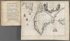
Oud-Groenland, of deszelfs Oo…
A map of Carolina, Florida an…
Nieuwe kaart van Suriname : v…
m
H.M.S. Aeolus and H.M.S. Norw…
A map of the icy sea in which…
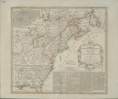
A new and correct map of the …
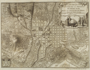
Plan de Quito Capitale de la …
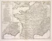
Gallia antiqua
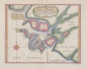
A Plan of the Straits of St. …
m
Long Island Sound
m
Plan of Dye Street
m
Crown Point
m
Cove
m
Spring Garden on Fair Street
m
The pasture
m
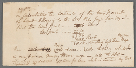
Note on two parcels of land b…
m
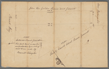
Ground near the school house …
m
A map of South Carolina and a…
A map of New England & ye cou…
Carte de la Louisiane
Carte de la Louisiane
Plan of the Bay of St. Joseph…
m
A new map of the River Missis…
m
A map of the most inhabited p…
A map of New England, and Nov…
The route of the army under t…
A map of the colonies of Conn…
m
Map of the road to Presqu'Isle
A new map of the Cherokee Nat…
m
Draft of the New Road from No…
Coste d'Afrique et les Isles …
m
Draughts of land in Amwell in…
m
Jon. Biddle's draught on Assu…
m
Coll. John Bryerly's draught …
m
Jon. Jewel's draught for 105 …
m
Draught of 1855 acres lying u…
m
Saml. Devenport & Elizath. Ro…
m
Draught of Gidion's Bickerdik…
m
James Freese's mapp of his lo…
m
John Biddle's survey of 472 a…
m
John Biddle's survey of 219 a…
m
Saml. Devenports draught & su…
m
Saml. Devenports tract as ye …
m
Saml. Devenports mapp of his …
A new and accurate map of the…
America Septentrionalis a Dom…
A draught of New York and Per…
A new and accurate map of Vir…
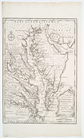
A map of the most inhabited p…
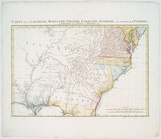
Carte de la Louisiane, Maryla…