Click to visit the main New York Public Library Homepage
The New York Public Library
Digital Collections
About Digital Collections
Browse
Search only public domain materials
Items
Collections
Divisions
Home
Search
Browse
About
Search only public domain materials
Items
Collections
Divisions
Digital Collections
Using Images
Using Data
Search
Filtered search
Show filters
Hide filters
Show Only Public Domain
topic
Maps
17
Landowners
16
Real property
16
Colonies
10
History
8
More
Less
name
Anville, Jean Baptiste Bourguignon d', 1697-1782
14
Jefferys, Thomas, -1771
10
Bellin, Jacques Nicolas, 1703-1772
9
Homann Erben (Firm)
9
Seale, Richard William
8
More
Less
collection
Maps of North America
88
Lawrence H. Slaughter Collection of English maps, charts, globes, books and atlases
34
Bancker plans
16
John H. Levine Collection
10
I. N. Phelps Stokes Collection of American Historical Prints
5
More
Less
place
North America
60
New Jersey
23
America
20
Great Britain
16
Early works to 1800
15
More
Less
genre
x
Maps
Surveys
31
Manuscript maps
17
land surveys
11
Prints
6
More
Less
publisher
s.n
12
s.n.,
6
publisher not identified
5
T. Jefferys
4
Akademiia
3
More
Less
division
Map Division
143
Manuscripts and Archives Division
20
Wallach Division: Picture Collection
5
Wallach Division: Print Collection
5
Rare Book Division
4
More
Less
type
cartographic
181
still image
6
text
6
Date Range
to
181 results found
Filtering on:
x
Date
: 1752 - 1764
x
Genre
: Maps
Sort by:
Title
Date created
Date digitized
Sequence
A map of Carolina, Florida an…
m
H.M.S. Aeolus and H.M.S. Norw…
A map of the icy sea in which…
Orbis romani pars orientalis
Tabula Italiæ antiquæ geograp…
Gallia antiqua
Asiæ, quæ vulgo Minor dicitur…
Græciæ antiquæ : specimen geo…
A general chart of all the co…
A Plan of the Straits of St. …
Parts of Ohio & Pennsylvania …
Carte reduite des costes de l…
m
Land cleared near Mr. Apthorp…
Plan of the bay and island of…
m
Church and Rutgers
m
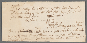
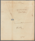
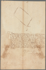
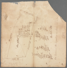
Tract divided for Peter Remsen
m
Road near Scott's
m
Colonel De Lancey's cleared l…
m
Long Island Sound
m
Crown Point
m
Cove
m
Kingston's ground on Long Isl…
m
Yellis Mandeville 65 acres ne…
m
Spring Garden on Fair Street
m
The pasture
m
Note on two parcels of land b…
m
Penet
m
Piece of ground near the ston…
m
Cleared ground - Colonel De L…
m
A map of South Carolina and a…
A map of New England & ye cou…
East Florida : from surveys m…
Carte de la Louisiane
Carte de la Louisiane
A plan of Bahia del Espiritu …
Plan of the town and harbour …
Plan de la Baye de Pensacola …
m
A new map of the River Missis…
A map of the new governments …
m
A map of the most inhabited p…
A map of New England, and Nov…
The route of the army under t…
A map of the colonies of Conn…
m
Map of the road to Presqu'Isle
A new map of the Cherokee Nat…
m
M. Stacy 1000 a. (survey of M…
m
Draughts of land in Amwell in…
m
Jon. Biddle's draught on Assu…
m
Jon. Jewel's draught for 105 …
m
Saml. Devenport & Elizath. Ro…