Click to visit the main New York Public Library Homepage
The New York Public Library
Digital Collections
About Digital Collections
Browse
Search only public domain materials
Items
Collections
Divisions
Home
Search
Browse
About
Search only public domain materials
Items
Collections
Divisions
Digital Collections
Using Images
Using Data
Search
Filtered search
Show filters
Hide filters
Show Only Public Domain
topic
Real property
7278
Fire insurance
4039
Cities & towns
3829
Administrative and political divisions
869
Railroads
717
More
Less
name
Sanborn Map Company
3830
Beers, F. W. (Frederick W.)
588
E. Robinson Co
385
Ullitz, Hugo
378
E.B. Hyde & Co
356
More
Less
collection
Atlases of New York City
6009
Maps of North America
2929
Atlases of the United States
2920
Maps of New York City and State
1618
Bancker plans
496
More
Less
place
New York (State)
8073
New York
1801
New York (N.Y.)
1011
Manhattan (New York, N.Y.)
852
Brooklyn (New York, N.Y.)
837
More
Less
genre
Maps
15568
Atlases
2861
Cadastral maps
562
Surveys
556
land surveys
442
More
Less
publisher
Sanborn Map Company
3958
publisher not identified
416
E. Robinson Co
297
E. Belcher Hyde
265
G.W. Bromley & Co
246
More
Less
division
Map Division
14228
Manuscripts and Archives Division
557
General Research Division
344
Rare Book Division
156
Schomburg Jean Blackwell Hutson Research and Reference Division
87
More
Less
type
x
cartographic
text
345
still image
209
Date Range
to
15,771 results found
Filtering on:
x
Date
: 1793 - 1906
x
Type
: cartographic
Sort by:
Title
Date created
Date digitized
Sequence
Results 501 - 550
Map showing the boundary of t…
m
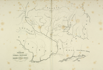
Map of the hydrographical bas…
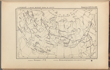
Priznaki granits I ukreplenii…
Region of Bone-Boiling and Sw…
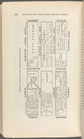
Kosmografiia.
Map of the city of San Jose
Map of the Great Salt Lake an…
Map of the lakes & drives aro…
Map of the Gogebic Iron Range…
Map of Wisconsin designed to …
H Diagram of the state of Mis…
m
Rand, McNally & Co.'s Minneso…
Plan of the city of Philadelp…
Sketch of the public surveys …
Rand, McNally & Co.'s Illinoi…
Map of the battlefield of Fre…
Washington and vicinity, Mary…
Map of the Rhode Island state…
Map of Conanicut Island, oppo…
Gardiner G. Hubbard's subdivi…
Johnson's Georgetown and the …
Portion of the Military depar…
A preliminary geological map …
Map showing the distribution …
Map of the extinct Lake Passa…
Water shed of the Passaic Riv…
Map of part of Jersey City, …
Colton's Georgetown and the c…
1892, Harrison's map of Jerse…
Harrison's map of Jersey City…
m
Map of property at Fairmount…
A map of the town of New-ark …
Rand, McNally & Co.'s New Jer…
Colton's excursion map of Nor…
Map of the boundary line betw…
Progress map of the state of …
Topographical map of that por…
Map of the railroads of Conne…
Phelps's national map of the …
Map of the western states to …
m
A new map of the western rive…
To accompany Willard's histor…
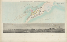
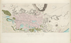
Planta topografica della citt…
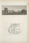
Rouine d'un Tempio d'Iside pr…
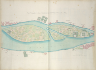
Pianta della città del Cairo.
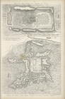
Pianta topografica di alcune …
Altra veduta di Carnac; Piant…
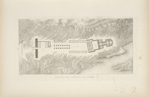
Pianta del tempio di Luxor.
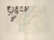
Piano generale di Tebe.
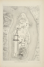
Pianta del tempio di File.
1
2
3
4
5
6
7
8
9
10
…
63
64
Previous
Next
1
2
3
4
5
6
7
8
9
10
…
63
64
Previous
Next