Click to visit the main New York Public Library Homepage
The New York Public Library
Digital Collections
About Digital Collections
Browse
Search only public domain materials
Items
Collections
Divisions
Home
Search
Browse
About
Search only public domain materials
Items
Collections
Divisions
Digital Collections
Using Images
Using Data
Search
Filtered search
Show filters
Hide filters
Show Only Public Domain
topic
Description and travel
20
Real property
14
Landowners
13
History
12
Antiquities
10
More
Less
name
Segato, Girolamo, 1792-1836
8
Valeriani, Domenico
8
Jomard, M. (Edme-François), 1777-1862
7
Napoleon I, Emperor of the French, 1769-1821
7
Catherwood, Frederick
6
More
Less
collection
Maps of North America
32
Atlante del basso ed alto Egitto
8
Description de l'Égypte: ou, Recueil des observations et des recherches qui ont été faites en Égypte pendant l'expédition de l'armée française
7
Incidents of travel in Yucatan: By John L. Stephens ... Illustrated by 120 engravings...
6
The pictorial field-book of the War of 1812; or, Illustrations, by pen and pencil, of the history, biography, scenery, relics, and traditions of the last war for American independence
5
More
Less
place
Egypt
24
United States
14
Ohio
8
Yucatán (Mexico : State)
6
Africa
5
More
Less
genre
x
Illustrations
Maps
84
Prints
51
Cadastral maps
12
Plans
4
More
Less
publisher
Harper & Brothers
12
nello stabilimento posto nei Fondacci di S. Spirito N. 1993
8
Impr. impériale
7
F. D. Pillot
4
Hachette et cie
4
More
Less
division
Map Division
35
General Research Division
28
Rare Book Division
24
Schomburg Manuscripts, Archives and Rare Books Division
13
Schomburg Jean Blackwell Hutson Research and Reference Division
12
More
Less
type
x
cartographic
still image
47
text
12
Date Range
to
120 results found
Filtering on:
x
Date
: 1801 - 1900
x
Genre
: Illustrations
x
Type
: cartographic
Sort by:
Title
Date created
Date digitized
Sequence
Turkey III: containing the So…
m
Atlas géologique
Ethnological Chart of the Wor…
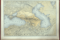
Carte generale du Caucase.
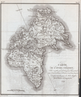
Carte de l'Ancien Continent.
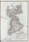
Carte du Nouveau Continent.
[La Carte]
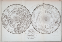
Carte des deux Régions Polair…
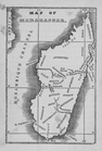
Map of Madagascar
Siege of Fort Meigs
Detroit River and vicinity
Plan of the Tippecanoe camp a…
Plan of the Battle of Fallen …
Battle of the Thames
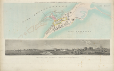
Plan of the city of Philadelp…
Planta topografica della citt…
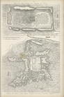
Rouine d'un Tempio d'Iside pr…
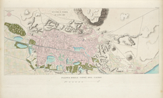
Pianta della città del Cairo.
Pianta topografica di alcune …
Altra veduta di Carnac; Piant…
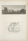
Pianta del tempio di Luxor.
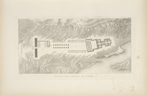
Piano generale di Tebe.
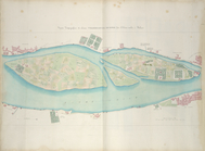
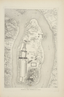
Pianta del tempio di File.
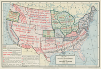
Map of free states, slave sta…
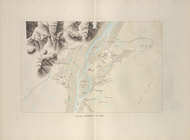
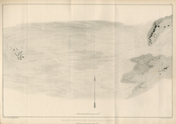
The Nile, from Assuan to the …
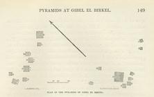
General plan of the pyramids …
Plan of the pyramids of Gibel…
New and improved map of the c…
Our centennial--plan of the g…
m
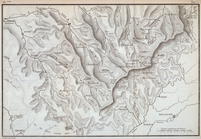
Topographical map of the coun…
m
Florance, George N
Plan of the city of Philadelp…
m
City of Toledo, Lucas Co., Oh…
Map of Cleveland and its envi…
Map of the city of Cleveland,…
Status of slavery in the Unit…
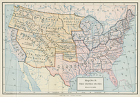
The United States, March 4, 1…
m
Rand, McNally & Co.'s new bus…
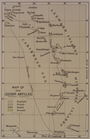
Map of the Lesser Antilles
Reconnaissance of the western…
m
Guide map of the city of Detr…
m
Map of Multnomah County, Oreg…
Colton's map of Oregon & Wash…
m
Map of Chickamauga & Chattano…
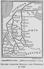
Routes through Indiana and Mi…
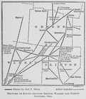
Network of routes through Gre…
m
City of Houston, Harris Co., …
Racial and Linguistic Map of …
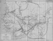
Carte de la Sénégambie et du …
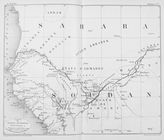
Carte du Soudan occidental.