Click to visit the main New York Public Library Homepage
The New York Public Library
Digital Collections
About Digital Collections
Browse
Search only public domain materials
Items
Collections
Divisions
Home
Search
Browse
About
Search only public domain materials
Items
Collections
Divisions
Digital Collections
Using Images
Using Data
Search
Filtered search
Show filters
Hide filters
Show Only Public Domain
topic
Post roads
14
Nautical charts
12
Administrative and political divisions
11
History
11
Description and travel
10
More
Less
name
Carey, Mathew, 1760-1839
48
Manning, Thomas S
44
Kruzenshtern, Ivan Fedorovich, 1770-1846
37
Jomard, M. (Edme-François), 1777-1862
35
Napoleon I, Emperor of the French, 1769-1821
33
More
Less
collection
Bancker plans
161
Maps of North America
81
Atlases, gazetteers, guidebooks and other books
48
Puteshestvie vokrug svieta v 1803, 4, 5 i 1806 godakh: po poveleniiu ego imperatorskago velichestva Aleksandra Pervago, nakorabliakh Nadezhde i Neve, pod nachalstvom... kapitana...Kruzenshterna
37
Description de l'Égypte: ou, Recueil des observations et des recherches qui ont été faites en Égypte pendant l'expédition de l'armée française
33
More
Less
place
Egypt
38
New York (State)
35
United States
34
New York (N.Y.)
26
New Jersey
22
More
Less
genre
Maps
501
Surveys
161
land surveys
129
Prints
68
Documents
32
More
Less
publisher
M. Carey
44
V Morskoi Tipografii
37
Impr. impériale
33
A. Bertrand
14
Published by A.T. Goodrich, 124 Broad Way
14
More
Less
division
Map Division
219
Manuscripts and Archives Division
168
Rare Book Division
41
Wallach Division: Art & Architecture Collection
37
General Research Division
18
More
Less
type
x
cartographic
text
38
still image
10
Date Range
to
508 results found
Filtering on:
x
Date
: 1809 - 1824
x
Type
: cartographic
Sort by:
Title
Date created
Date digitized
Sequence
Plan of the town of Paramarib…
Isothermal chart, or, View of…
m
A chart of the discoveries of…
Map and survey of lands of up…
Great Falls of Columbia River
Plan of the town of York Haven
Settlements of the Swiss past…
m
Carte d'une partie de l'Etat …
Map of the American Coast, fr…
Plan of the city and fortific…
East India Islands
Ancient Italy
Countries adjacent to the Med…
Environs du Kaire [Cairo]. Pl…
Sketch of the action on the h…
Sketch of the action on the h…
Chart of the world, on Mercat…
m
Le Kaire: Plan particulier de…
Map of the state of Missouri …
Plan of private claims in Mic…
Map of the states of Indiana …
Shelton & Kensett's map of th…
m
A map of the state of Louisia…
m
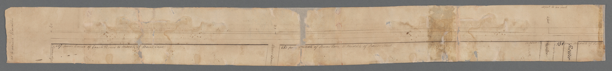
Hendrick's lot in Beaver Stre…
m
Bowery Lane
m
Plot on Bowery lane
m
Lots near Amity Street, Broad…
m
1810 January 8
m
1810 January 7
m
Between Lispenard and Leonard…
m
Plan of a House at Number 5 H…
m
Colonel Magregor's at Greenwi…
m
Greenwich Street between Dyes…
m
College ground and lots
m
Malleshaw's near Fresh Water
m
Sketches showing grades and d…
m
Brookland
m
Computations of Staten Island
m
Survey of a tract of land
m
Hawken's and Wood's meadow
m
Caleb Wood's farm
m
Daniel, Ebenezar Bowers's, an…
m
Table of a map to be annexed …
m
Thomas Smith's meadow
m
Land adjoining Hudson River a…
m
Calculations for Dr. Bard
m
Part of Vermont
m
Division line between W. N. a…
m
Peter Goelet's near the long …
m
James De Lancey's meadow
1
2
3
Previous
Next
1
2
3
Previous
Next