Click to visit the main New York Public Library Homepage
The New York Public Library
Digital Collections
About Digital Collections
Browse
Search only public domain materials
Items
Collections
Divisions
Home
Search
Browse
About
Search only public domain materials
Items
Collections
Divisions
Digital Collections
Using Images
Using Data
Search
Filtered search
Show filters
Hide filters
Show Only Public Domain
topic
Real property
83
Landowners
56
Administrative and political divisions
36
Railroads
33
History
27
More
Less
name
Königlich Preussisch privilegirte Fallersche Schauspieler-Gesellschaft
8
Gavit, John E., 1817-1874
6
Hayward, George, approximately 1800-
6
Pease, Richard H., 1813-1869
6
Ackerman Lithr
5
More
Less
collection
Maps of North America
220
Maps of New York City and State
72
Yiddish theater collection
8
place
New York (State)
59
Massachusetts
49
Pennsylvania
19
Boston
17
Michigan
17
More
Less
genre
Maps
292
Cadastral maps
68
Geological maps
13
Facsimiles
8
Posters
8
More
Less
publisher
x
publisher not identified
Lith of R.H. Pease
2
D. McLellan, lithographer
1
Engraved & Printed by J. E.Gavit
1
Lith. by Berggoetz & Co
1
More
Less
division
Map Division
292
Dorot Jewish Division
8
type
cartographic
292
text
12
still image
6
Date Range
to
300 results found
Filtering on:
x
Date
: 1814 - 1879
x
Publisher
: publisher not identified
Sort by:
Title
Date created
Date digitized
Sequence
A bird's-eye view of the city…
A compleat map of North-Carol…
A geological map of a part of…
A geological map of Massachus…
A map of a tract of land in t…
A map of part of Alabama & Fl…
A map of part of Alabama & Fl…
A map of part of the land in …
A map of part of the Province…
A map of the state of Virgini…
A map of the Virginia Central…
A mappe of Colonel Römers voy…
A mappe of Colonel Römers voy…
A plan of Greenville, Norwich…
A Plan of the action at Bunke…
A plan of the Manor of Philip…
A plan of the operations of t…
A plan of the salt marsh and …
A plan of the town of Pittsfo…
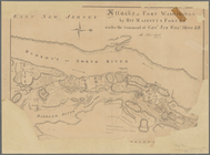
A prospective view of the bat…
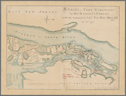
A prospective view of the bat…
A topographical map of the st…
Aboriginal America east of th…
Alaska and adjoining region
Americae septentrionalis pars…
Antietam
Approach of the Union Armies …
Atherton, St. Lawrence County…
Attacks of Fort Washington by…
Attacks of Fort Washington by…
Boston and Albany Rail Road: …
Brattleboro and vicinity : co…
m
Brooklyn City Hall
m
Bureau of roads
Carta particolare della nuoua…
Charleston : a map showing th…
m
Charleston District, South Ca…
m
Charleston Harbour and the ad…
Chart of Narraganset Bay : su…
Chengwatana, Pine County, M.T…
Chicago : correctly copied fr…
City of Apalachicola and its …
City of Covington
City of New Haven
Connecticut
County and railroad map of th…
Diagram of the state of Misso…
Duncan's addition to Michigan…
Eagle Harbor Copper Co, and E…
Engineers map of the state of…
1
2
Previous
Next
1
2
Previous
Next