Click to visit the main New York Public Library Homepage
The New York Public Library
Digital Collections
About Digital Collections
Browse
Search only public domain materials
Items
Collections
Divisions
Home
Search
Browse
About
Search only public domain materials
Items
Collections
Divisions
Digital Collections
Using Images
Using Data
Search
Filtered search
Show filters
Hide filters
Show Only Public Domain
topic
History
116
Railroads
60
Administrative and political divisions
21
Indian reservations
16
Boundaries
13
More
Less
name
American Civil War (1861-1865)
29
United States. Army. Corps of Topographical Engineers
19
Bien, Julius, 1826-1909
17
United States Coast Survey
16
Gannett, Henry, 1846-1914
14
More
Less
collection
Maps of North America
290
Maps of New York City and State
18
Atlases of the United States
9
The pictorial field-book of the War of 1812; or, Illustrations, by pen and pencil, of the history, biography, scenery, relics, and traditions of the last war for American independence
5
Die Sklavenmacht. Blicke in die Geschichte der Vereinigten Staaten von Amerika. Zur Erklarung der Rebellion von 1860-65
2
More
Less
place
x
United States
Virginia
45
Canada
24
New York (State)
18
Mexico
16
More
Less
genre
Maps
333
Topographic maps
13
Illustrations
12
Atlases
9
Military maps
9
More
Less
publisher
publisher not identified
17
U.S. Geological Survey
11
Corps of Topographical Engineers
10
U.S. Light-House Board
10
J.H. Colton
8
More
Less
division
Map Division
317
Rare Book Division
5
Schomburg Jean Blackwell Hutson Research and Reference Division
4
Schomburg Manuscripts, Archives and Rare Books Division
3
Manuscripts and Archives Division
2
More
Less
type
x
cartographic
still image
9
text
7
Date Range
to
333 results found
Filtering on:
x
Date
: 1850 - 1899
x
Place
: United States
x
Type
: cartographic
Sort by:
Title
Date created
Date digitized
Sequence
Map of Camp Chase. Drawn on a…
Map illustrating the operatio…
Siege of Fort Meigs
Detroit River and vicinity
Plan of the Tippecanoe camp a…
Plan of the Battle of Fallen …
Battle of the Thames
Map of the Gogebic Iron Range…
Map of the boundary line betw…
Phelps's national map of the …
m
United States
Skeleton map of the overland …
Map showing condition and pro…
Map of the frontiers of the n…
Map of free states, slave sta…
Map of the port & vicinity of…
A.R. Roessler's latest map of…
Map of the White Mountains of…
m
Dakota Territory
Map of the Department of Dako…
Territory of Dakota
Plan of the French and Americ…
Map exhibiting the fixed loca…
m
Map of the St. Clair River : …
m
Map of the river Sainte Mary …
Lake St. Clair
No. 3, map of Isle Royale in …
Detroit 1820
Map of the Black Hills : from…
Cram's sectional map of Dakot…
Ceded part of Dakota Territor…
Position de l'armée Américain…
Territory of Dakota
A sketch of the operations of…
Map of New York City and of M…
Plan of the Battle of Long Is…
A topographical map of the no…
Battle of Long Island: from S…
Johnson's Nebraska, Dakota, I…
Barometric profile of the rou…
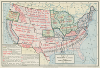
Status of slavery in the Unit…
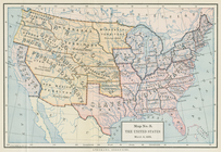
The United States, March 4, 1…
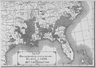
Map showing the relation exis…
Map of Washington Territory
Map of Washington Territory :…
Boston with its environs
m
Colton's map of the United St…
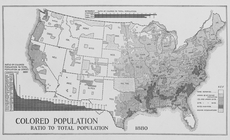
Colored population ratio to t…
Eastern Tennessee, with parts…
J.H. Colton's topographical m…
1
2
Previous
Next
1
2
Previous
Next