Click to visit the main New York Public Library Homepage
The New York Public Library
Digital Collections
About Digital Collections
Browse
Search only public domain materials
Items
Collections
Divisions
Home
Search
Browse
About
Search only public domain materials
Items
Collections
Divisions
Digital Collections
Using Images
Using Data
Search
Filtered search
Show filters
Hide filters
Show Only Public Domain
topic
x
History
Real property
72
Business enterprises
67
Boundaries
7
Fortification
4
More
Less
name
Beers, F. W. (Frederick W.)
67
Batiushkov, P. N. (Pompeĭ Nikolaevich) (1811-1892)
9
Barclay, Anthony, 1792-1877
7
Porter, Peter B. (Peter Buell), 1773-1844
7
United States. Light-House Board
7
More
Less
collection
Atlases of the United States
67
Maps of North America
26
Maps of New York City and State
10
Pamiatniki stariny v zapadnykh guberniakh imperii
9
Division and reunion, 1829-1889
2
place
New York (State)
74
Orange County
67
Orange County (N.Y.)
67
United States
24
Vilnius (Lithuania)
9
More
Less
genre
Maps
82
Atlases
67
Prints
41
Illustrations
5
Cadastral maps
4
More
Less
publisher
Andreas, Baskin & Burr
67
Izd. Ministerstvom vnutrennikh del
9
U.S. Light-House Board
7
publisher not identified
6
A.S. Barnes & Co
2
More
Less
division
Map Division
103
Rare Book Division
9
Schomburg Jean Blackwell Hutson Research and Reference Division
2
type
x
cartographic
text
8
still image
3
Date Range
to
114 results found
Filtering on:
x
Date
: 1871 - 1894
x
Topic
: History
x
Type
: cartographic
Sort by:
Title
Date created
Date digitized
Sequence
m
Dakota Territory
Plan of the French and Americ…
m
Map of the St. Clair River : …
m
Map of the river Sainte Mary …
Lake St. Clair
No. 3, map of Isle Royale in …
Detroit 1820
Position de l'armée Américain…
Map of New York City and of M…
Plan of the Battle of Long Is…
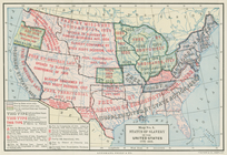
Status of slavery in the Unit…
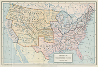
The United States, March 4, 1…
Map showing the location of b…
Battle of Long Island
Department of Arizona, Sheet …
[Pla]n of the Siege of Yorkto…
Map of the American colonies …
m
Map of Elizabeth City Co., Va…
Plan of the French and Americ…
Map of the vicinity of Richmo…
Statistical map of the United…
Gen. Washington's Revolutiona…
Plan of the town of Worcester…
Kentucky et Tennessee
Plan of the siege of Savannah…
New Orleans : map of the revo…
Charts and plans illustrating…
Plan der Descente und der Aff…
Plan of West Point
Historical sketch map of King…
Plan of the town of Boston an…
Centennial map of Concord, 17…
Historical map of Nantucket
Milford in 1646: [Connecticut]
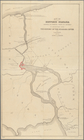
Map of historic Niagara: show…
The second section of the sur…
m
Niagara 1819
m
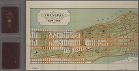
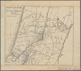
The Transval of New York
The Middletown Mercury. Two D…
The Horse Guy Miller, Owned b…
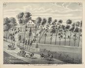
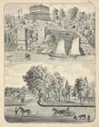
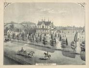
Willow Grove - Residence of B…
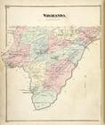
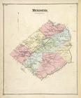
Wawayanda [Township]
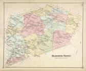
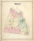
Blooming Grove [Township]
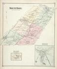
Mounr Hope [Township]; Mount …
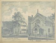
Parry House, Highland Falls, …
Residence of Edwin Parmelee, …
Minisink [Township]
Highland [Township]
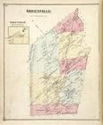
Greenville [Township]; Greenv…
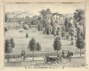
Res. of B. F. Dunning, Warwic…