Click to visit the main New York Public Library Homepage
The New York Public Library
Digital Collections
About Digital Collections
Browse
Search only public domain materials
Items
Collections
Divisions
Home
Search
Browse
About
Search only public domain materials
Items
Collections
Divisions
Digital Collections
Using Images
Using Data
Search
Filtered search
Show filters
Hide filters
Show Only Public Domain
topic
History
7
Railroads
7
Transportation
4
Lighthouses
3
Surveys
2
More
Less
name
Geological Survey (U.S.)
7
Gannett, Henry, 1846-1914
5
Andrew B. Graham Co
3
Julius Bien & Co
3
United States. Light-House Board
3
More
Less
collection
Maps of North America
27
William J. Wilgus papers
4
Maps of New York City and State
2
Atlas of the illustrated building laws of the principal cities of the United States
1
Atlases of the United States
1
More
Less
place
x
United States
New York (State)
6
New York
5
New York (N.Y.)
4
Manhattan (New York, N.Y.)
2
More
Less
genre
Maps
37
Topographic maps
4
Books
1
Cadastral maps
1
Charts
1
More
Less
publisher
U.S. Geological Survey
7
U.S. Light-House Board
3
A.C. Austin Eng. Co
1
Albemarle and Chesapeake Canal Company
1
American Lithographic Company
1
More
Less
division
Map Division
30
Manuscripts and Archives Division
4
Schomburg Jean Blackwell Hutson Research and Reference Division
2
General Research Division
1
type
x
cartographic
text
4
still image
2
Date Range
to
37 results found
Filtering on:
x
Date
: 1895 - 1934
x
Place
: United States
x
Type
: cartographic
Sort by:
Title
Date created
Date digitized
Sequence
Map and profile showing sourc…
Map of Proposed Belt Railways…
Preliminary Study for a Great…
Map showing relation of the I…
H4. Map (Scheme B) illustrati…
m
United States
Map showing condition and pro…
A topographical map of the no…
Map showing the relation exis…
Boston with its environs
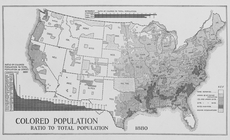
Colored population ratio to t…
Map of the Albemarle and Ches…
Map of revolutionary camp gro…
m
Map of Chickamauga & Chattano…
Eastern Virginia showing the …
Map showing condition and pro…
The route of the army under t…
United States contour map
United States relief map
Territory covered by the prin…
United States and territories…
First l. h. district
Second l. h. district
United States light-house est…
Crawford's map of the White M…
Mt. Washington and vicinity: …
m
The Matthews-Northrup up-to-d…
Vereinigte Staaten von Nord-A…
m
History of the United States:…
United States base map
Territorial groups of the Uni…
m
Weather map, January 9, 1886:…
m
Atlas of the illustrated buil…
Amerikanisch-Spanischer krieg…
"Underground" routes to Canad…
m
U.S. tour book: [a reproducti…
m
United States and territories…
End of results
|
Top