Click to visit the main New York Public Library Homepage
The New York Public Library
Digital Collections
About Digital Collections
Browse
Search only public domain materials
Items
Collections
Divisions
Home
Search
Browse
About
Search only public domain materials
Items
Collections
Divisions
Digital Collections
Using Images
Using Data
Search
Filtered keyword search
Show filters
Hide filters
Show Only Public Domain
topic
Real property
12
Landowners
8
Buildings
2
Real propery auctions
2
Administrative and political divisions
1
More
Less
name
G.W. Bromley & Co
5
H.F. Walling's Map Establishment
2
Smith, Gallup & Co
2
Walling, Henry Francis, 1825-1888
2
Bartlett, L. L. (Lewis L.), 1809-1888
1
More
Less
collection
Atlases of New York City
5
Maps of New York City and State
5
Collection of broadside real estate maps announcing auctions of lots in early 19th century New York City
2
Maps of North America
2
place
New York (State)
7
New York
6
Queens (New York, N.Y.)
6
New York (N.Y.)
5
Brooklyn (New York, N.Y.)
3
More
Less
genre
x
Cadastral maps
Maps
14
Pictorial works
2
Manuscript maps
1
publisher
G. W. Bromley & Co
5
Smith, Gallup & Co
2
publisher not identified
2
E.T. Quititch
1
John Douglass
1
More
Less
division
x
Map Division
type
cartographic
14
still image
1
text
1
Date Range
to
14 results found for:
x
east river
Filtering on:
x
Division
: Map Division
x
Genre
: Cadastral maps
Sort by:
Relevance
Title
Date created
Date digitized
Sequence
m
… into the
East
River
abstract:
…., and the
East
River
. Includes
m
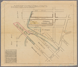
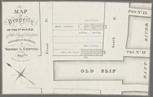
Map of 26 lots of ground in t…
abstract:
…, Stanton Street,
East
River
m
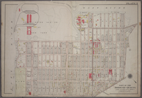
Plate 1: Bounded by (
East
River
)
River
Map of property in the 1st wa…
abstract:
Front Street, South Street,
East
River
, Old
m
Plate 2: Bounded by (
East
River
) Vernon
m
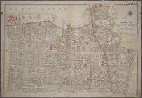
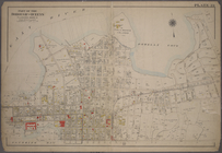
Map of the village of Astoria…
abstract:
… by the
East
River
, 24th Ave
…, Woolsey Avenue and (
East
River
) Barclay Street.
collection:
… Avenue and (
East
River
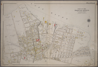
Plate 23: Bounded by (
East
River
) Avenue G
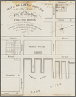
Map of property belonging to …
abstract:
….,
East
River
, and Union
Plate 25: Bounded by (
East
River
)26th Street
m
Map of the city of Williamsbu…
abstract:
… Clinton Avenue to
East
River
.
m
Map of the county of Berkshir…
note:
… of Berkshire County;
East
Otis; Southfield; Mill
River
Map of the county of Berkshir…
note:
… of Berkshire County;
East
Otis; Southfield; Mill
River
m
Map of Suffolk Co., L.I., New…
note:
… -- Patchogue --
East
Setauket --
River
Head -- Southold
End of results
|
Top