Click to visit the main New York Public Library Homepage
The New York Public Library
Digital Collections
About Digital Collections
Browse
Search only public domain materials
Items
Collections
Divisions
Home
Search
Browse
About
Search only public domain materials
Items
Collections
Divisions
Digital Collections
Using Images
Using Data
Search
Filtered keyword search
Show filters
Hide filters
Show Only Public Domain
topic
Real property
18
Landowners
13
Administrative and political divisions
5
Cities and towns
4
Nautical charts
4
More
Less
name
Beers, F. W. (Frederick W.)
3
H.F. Walling's Map Establishment
3
Prindle, A. B
3
Rease, W. H
3
United States Coast Survey
3
More
Less
collection
Maps of North America
36
Atlases, gazetteers, guidebooks and other books
5
Atlases of New York City
3
Atlases of the United States
1
Lawrence H. Slaughter Collection of English maps, charts, globes, books and atlases
1
More
Less
place
Ohio
7
California
6
Pennsylvania
4
Philadelphia
4
Philadelphia (Pa.)
4
More
Less
genre
x
Illustrations
Maps
39
Cadastral maps
13
Prints
3
Tourist maps
3
More
Less
publisher
publisher not identified
4
F. W. Beers, A. D. Ellis & others
3
C.P. Gray
2
Dakin Pub. Co
2
Lee & Marsh
2
More
Less
division
x
Map Division
type
cartographic
40
still image
40
text
8
Date Range
to
47 results found for:
x
map
Filtering on:
x
Division
: Map Division
x
Genre
: Illustrations
Sort by:
Relevance
Title
Date created
Date digitized
Sequence
m
Map
of Columbiana County, Ohio, 1860 …
note:
… along center of
map
Octagonal
map
of the environs of Richmond
note:
Mapping
the Nation (NEH grant, 2015-2018)…
Colton's
map
of Oregon & Washington
note:
… catalog of the
Map
Map
of the city of Stockton …
note:
NYPL
Map
Div. copy mounted on muslin
Plan of the city of Philadelp…
note:
NYPL
Map
Div. copy: margins trimmed; sheet 51
Map
of La Presa …
note:
… catalog of the
Map
m
Map
of Stockton, Cal.
note:
… catalog of the
Map
Map
of the city of Davenport and its suburbs
note:
… catalog of the
Map
A
Map
of America between latitudes 40
note:
Mapping
the Nation (NEH grant, 2015-2018)…
m
Map
of Multnomah County, Oregon …
note:
NYPL
Map
Div. copy includes manuscript
m
A topographical
map
of Lincoln Co. Maine
note:
NYPL
Map
Div. copy
Leavitt's
map
with views of the White
note:
Pictorial
map
of the White Mountains with 4
m
A correct
map
of the state of Vermont, from
note:
NYPL
Map
Div. copy
m
…
map
of Montana
note:
NYPL
Map
Div. copy has accession no
Map
of Clinton County, Ohio …
note:
NYPL
Map
Div. copy imperfect: brittle
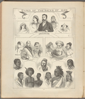
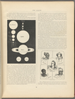
Types of the races of man
note:
Maps
by George F. Cram.
The Earth
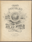
Cram's unrivaled atlas of the…
Map
of Cleveland and its environs …
note:
… catalog of the
Map
Map
of Perry County, Ohio …
note:
…. Walling's
Map
Plan of the city of Philadelp…
note:
… catalog of the
Map
m
Map
of the Yellowstone National Park …
note:
NYPL
Map
Div. copy imperfect: part of margin
m
Guide
map
of the city of Detroit …
note:
…. Dictionary catalog of the
Map
m
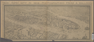
New York City in 1909: photog…
collection:
Maps
of New York City and State
Map
of the city of Cleveland, Ohio …
note:
NYPL
Map
Div. copy has accession no
m
City of Toledo, Lucas Co., Oh…
note:
… catalog of the
Map
A
map
of New England & ye country
note:
Mapping
the Nation (NEH grant, 2015-2018)…
m
Map
of Trumbull County, Ohio …
note:
Library of Congress. Land ownership
maps
Our centennial--plan of the g…
note:
NYPL
Map
Div. copy: right margin with source
m
Map
number sixteen …
note:
Mapping
the Nation (NEH grant, 2015-2018)…
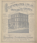
New Illustrated Atlas of Dutc…
Ethnological Chart of the Wor…
m
Map
of Chickamauga & Chattanooga National Park …
note:
Mapping
the Nation (NEH grant, 2015-2018)…
Reconnaissance of the S.E. en…
note:
NYPL
Map
Div. copy has accession no
A new and correct
map
of Connecticut
note:
… catalog of the
Map
Turkey III: containing the So…
collection:
Maps
of the Society for the Diffusion of Useful
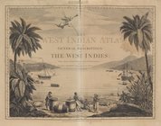
The West-India atlas..., [Fro…
collection:
… charts and
maps
, taken
Johnson's North Carolina and …
note:
Mapping
the Nation (NEH grant, 2015-2018)…
m
City of Houston, Harris Co., …
note:
Mapping
the Nation (NEH grant, 2015-2018)…
New and improved
map
of the city
note:
NYPL
Map
Div. copy stamped in 2 places over
m
Topographical
map
of the county of Penobscot
note:
NYPL
Map
Div. copy is divided into 6 sheets, 79
Reconnaissance of the western…
note:
… catalog of the
Map
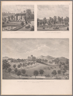
Plate 73: Residence of A.S. D…
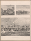
Property of F.A. Halstead, Be…
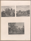
Old Dutch Church, Sleepy Holl…
Reconnaissance of the western…
note:
… catalog of the
Map
Map
of Waldo County, Maine
note:
Mapping
the Nation (NEH grant, 2015-2018)…
End of results
|
Top