Click to visit the main New York Public Library Homepage
The New York Public Library
Digital Collections
About Digital Collections
Browse
Search only public domain materials
Items
Collections
Divisions
Home
Search
Browse
About
Search only public domain materials
Items
Collections
Divisions
Digital Collections
Using Images
Using Data
Search
Filtered search
Show filters
Hide filters
Show Only Public Domain
topic
Real property
6800
Fire insurance
5108
Cities & towns
4839
Administrative and political divisions
655
Railroads
603
More
Less
name
Sanborn Map Company
4933
Ullitz, Hugo
451
G.W. Bromley & Co
414
E.B. Hyde & Co
349
Bromley, George Washington
339
More
Less
collection
Atlases of New York City
7372
Maps of North America
1916
Atlases of the United States
1453
Maps of New York City and State
1375
Lawrence H. Slaughter Collection of English maps, charts, globes, books and atlases
221
More
Less
place
New York (State)
7758
New York
1774
New York (N.Y.)
1457
Brooklyn (New York, N.Y.)
742
Manhattan (New York, N.Y.)
513
More
Less
genre
Maps
12444
Atlases
1448
Cadastral maps
391
Topographic maps
108
Geological maps
91
More
Less
publisher
Sanborn Map Company
4967
E. Belcher Hyde
570
G.W. Bromley & Co
408
publisher not identified
240
New York (N.Y.). Board of Estimate and Apportionment
185
More
Less
division
x
Map Division
type
cartographic
12361
text
190
still image
152
Date Range
to
12,542 results found
Filtering on:
x
Division
: Map Division
x
Note
: NYPL Map Div. copy has accession no. stamped in lower left corner: 22254. Label pasted on verso : "Land Office, map of Minnesota.The property of U.H. Painter."
Sort by:
Title
Date created
Date digitized
Sequence
m
Map of the Cedar Knolls, at B…
A map of Dutch settlements of…
Map of Saratoga County
Acres of Land, Population, Dw…
Burnt Hills [Village]; Burnt …
Map of the borough of Brookly…
m
Maps of the Society for the D…
Maps of the Society for the D…
Maps of the Society for the D…
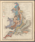
Geological map of England and…
m
Maps of the Society for the D…
m
Maps of the Society for the D…
m
Maps of the Society for the D…
m
Johnson's Physical Map
Ethnographic map of the world…
m
Mercator projection exhibitin…
m
A chart of the discoveries of…
m
Hammond's complete map of Bro…
Map of the borough of Brookly…
Hammond's handy reference map…
Map of the borough of Brookly…
m
Map of the borough of Brookly…
m
Freight map of the metropolit…
Hammond's complete map of New…
m
Map of property belonging to …
Map of lots belonging to the …
Map of Brooklyn Manor
Map of New York City and vici…
m
Map of Brooklyn
The Cord Meyer Development Co…
m
Petersen's map of Brooklyn
Map of Flatbush Meadows : sit…
m
The Blanchard Press correctly…
Map of the comprehensive plan…
Rand, McNally & Co.'s new aut…
Williams' map of Borough of B…
Map and profile showing sourc…
The Evening Mail's complete m…
m
The John Wanamaker automobile…
m
Official map covering territo…
Map of Jamaica in the 4th war…
m
Rand, McNally & Co.'s complet…
Map of the suburban territory…
Road map of the New York dist…
Map of property New York Dock…
Brooklyn, from Rand McNally m…
m
Map showing 100 miles around …
Hagstrom's map of lower New Y…
Rand McNally official 1921 au…
Hammond's handy reference map…
1
2
3
4
5
6
7
8
9
10
…
50
51
Previous
Next
1
2
3
4
5
6
7
8
9
10
…
50
51
Previous
Next