Click to visit the main New York Public Library Homepage
The New York Public Library
Digital Collections
About Digital Collections
Browse
Search only public domain materials
Items
Collections
Divisions
Home
Search
Browse
About
Search only public domain materials
Items
Collections
Divisions
Digital Collections
Using Images
Using Data
Search
Filtered keyword search
Show filters
Hide filters
Show Only Public Domain
topic
Nautical charts
3
Coasts
2
Cuba
1
name
Hooker, William
2
Bew, John, -1793
1
Blunt, Edmund M. (Edmund March) (1770-1862 )
1
Blunt, Edmund M. (Edmund March), 1770-1862
1
Carl Flemming (Firm)
1
More
Less
collection
Maps of North America
5
Atlases, gazetteers, guidebooks and other books
1
Lawrence H. Slaughter Collection of English maps, charts, globes, books and atlases
1
place
Bahamas
5
Florida
3
Atlantic Coast (U.S.)
2
Cuba
2
Florida, Straits of
2
More
Less
genre
Maps
7
Nautical charts
2
publisher
Carl Flemming, Verlag, Buch- und Kunstdruckerei
1
Dépôt general de la Marine
1
Illustrated London News & Sketch Ltd.?
1
Paniconographie de Gillot
1
Published for & sold by Wm. Hooker, 202 Water Street
1
More
Less
division
x
Map Division
type
cartographic
7
Date Range
to
7 results found for:
x
Bahamas
Filtering on:
x
Division
: Map Division
Sort by:
Relevance
Title
Date created
Date digitized
Sequence
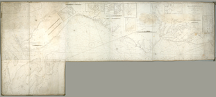
To the members of the Nautica…
note:
… covering
Bahamas
.
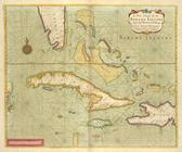
A new chart of the
BAHAMA
ISLANDS
Carte réduite des côtes et de…
abstract:
… of Cuba and the
Bahamas
To the members of the Nautica…
… den
Bahama
-Inseln und
…. Domingo and the
Bahama
A map of East and West Florid…