Click to visit the main New York Public Library Homepage
The New York Public Library
Digital Collections
About Digital Collections
Browse
Search only public domain materials
Items
Collections
Divisions
Home
Search
Browse
About
Search only public domain materials
Items
Collections
Divisions
Digital Collections
Using Images
Using Data
Search
Filtered keyword search
Show filters
Hide filters
Show Only Public Domain
topic
x
Nautical charts
Harbors
51
Coasts
37
Navigation
30
Rivers
7
More
Less
name
United States Coast Survey
197
Bache, A. D. (Alexander Dallas), 1806-1867
170
Mathiot, G
47
Alden, James, 1810-1877
31
Maffitt, John Newland, 1819-1886
24
More
Less
collection
Maps of North America
214
Maps of New York City and State
19
place
Massachusetts
27
California
25
Virginia
22
Atlantic Ocean
20
Florida
20
More
Less
genre
x
Maps
Nautical charts
197
Bathymetric maps
98
Illustrations
3
Topographic maps
2
More
Less
publisher
U.S. Coast Survey
95
U.S. Coast Survey Office
51
United States Coast Survey
21
The Survey
6
Coast Survey Office
5
More
Less
division
Map Division
233
type
cartographic
233
still image
7
text
1
Date Range
to
233 results found for:
x
Washington (State)
Filtering on:
x
Genre
: Maps
x
Topic
: Nautical charts
Sort by:
Relevance
Title
Date created
Date digitized
Sequence
… Harbor,
Washington
Ter. …
… of the United
States
, from Gray
abstract:
… in
Washington
State
. Relief
… of the United
States
(northern
… of the United
States
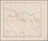
Reconnaissance of Grenville Harbor,
Washington
Reconnaissance of Olympia Harbor,
Washington
America, N.W. Coast, Strait o…
note:
…
States
Exploring
…,
Washington
Ter. …
collection:
Reconnaissance of Semi-ah-moo Bay,
Washington
…,
Washington
Ter. …
note:
…
States
; triangulation
…,
Washington
Ter. …
…'s Island,
Washington
…
Reconnaissance of Canal de Ha…
collection:
Washington
Map of the mouth of Great Sod…
note:
….
Washington
, 1843. Map no. 8
Map of Buffalo Harbor, N.Y., …
collection:
Maps of New York City and
State
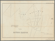
Sketch of West Pier, Oswego H…
collection:
Senate executive document (United
States
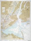
Bay and harbor of New York
collection:
Maps of New York City and
State
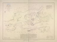
Hell Gate and its approaches
note:
…
States
.
Oswego Harbor, 33d Congress, …
collection:
Ex. doc. (United
States
. Congress. House)…
Middle part of Long Island So…
note:
…
States
; A.D. Bache
m
Eastern part of Long Island S…
note:
…
States
; A.D. Bache
State
of Ohio …
note:
… Engineers at
Washington
A map of the extremity of Cap…
note:
… Engineers,
Washington
Coast chart, no. 118, Napeagu…
collection:
Maps of New York City and
State
Middle part of the southern c…
note:
…
States
.
m
United
States
--east coast, New York--New
note:
…
States
--east coast, New
Eastern part of the southern …
note:
…
States
.
1889, Larchmont Harbor, N.Y.:…
collection:
Maps of New York City and
State
Western part of the southern …
note:
… of the United
States
.
Long Island Sound (western sh…
note:
…
States
.
Chart of the Columbia River f…
abstract:
…
States
. Congress. Senate
Map of the coast of Massachus…
note:
….
Washington
: [1872?]
m
Map of New-York Bay and Harbo…
note:
…
States
; triangulation
Reconnaissance of Port Royal …
collection:
States
General chart of Alaska : com…
abstract:
… United
States
and Russian
Preliminary survey of the ent…
collection:
States
Entrance to Columbia River, O…
collection:
States
Preliminary chart of Ship Isl…
collection:
States
Reconnaissance of Romerly Mar…
collection:
States
m
Map of New-York Bay and Harbo…
note:
…
States
; triangulation
Boston Harbor, Massachusetts:…
note:
Prime meridian: Boston
State
House.
Nantucket Sound: western part
collection:
States
The harbor of Holmes' Hole: t…
note:
…
States
.
Preliminary chart of Winyah B…
collection:
States
Unfinished proof of Narragans…
note:
[United
States
Coast Survey], A.A
Chart of the mouth of Susqueh…
collection:
States
Preliminary survey of Humbold…
abstract:
… of the United
States
Coast Survey.
Washington
, D.C
m
… of the United
States
, from
Preliminary chart of Beaufort…
collection:
States
…
States
Boston Harbor, Massachusetts
note:
…
States
.