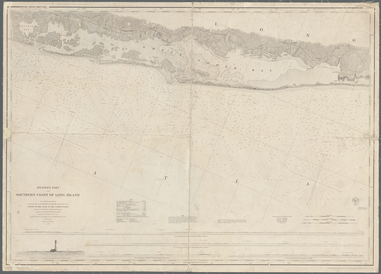
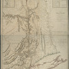
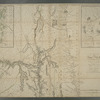
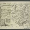
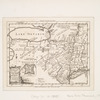
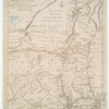
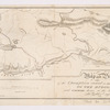
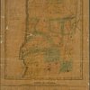
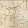
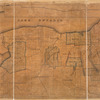
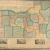
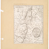
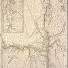
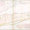
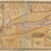
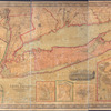
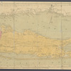
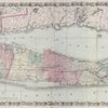
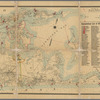
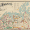
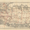
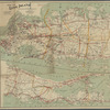
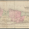
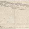
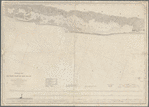
TitleWestern part of the southern coast of Long Island: from a trigonometrical survey
Additional title: Southern coast of Long Island
NamesUnited States Coast Survey (Publisher)Hassler, F. R. (Ferdinand Rudolph), 1770-1843 (Creator)Bénard, Ch. (Charles) (Creator)Dickens, H. L. (Creator)Gedney, Thomas R., -1857 (Creator)Woodhull, M. (Maxwell) (Creator)Bache, Richard Meade (Creator)Bache, A. D. (Alexander Dallas), 1806-1867 (Creator)Ricketts, James J. (Draftsman)Gerdes, F. H. (Draftsman)Knight, John, approximately 1802-1872 (Engraver)Lawson, Oscar A., 1813-1854 (Engraver)Dankworth, Frederick, approximately 1804- (Engraver)Mathiot, G. (Printer)
CollectionMaps of New York City and State
Parts
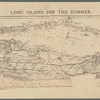
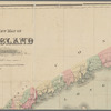
Long Island
Dates / OriginDate Issued: 1851Place: Washington, D.C.Publisher: United States Coast Survey
Library locationsLionel Pincus and Princess Firyal Map DivisionShelf locator: Map Div. 16-730
TopicsNautical charts -- New York (State) -- Long Island (N.Y.)Nautical charts -- New York (State) -- Suffolk CountyNautical charts -- New York (State) -- NassauLong Island (N.Y.)
GenresMapsNautical charts
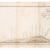
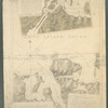
NotesStatement of responsibility: under the direction of F.R. Hassler and A.D. Bache superintendent of the Survey of the Coast of the United States.Content: Relief shown by hachures & land forms; depths by soundings.Content: Oriented with north to the upper right.Content: Includes notes, charts and 5 coastal panoramas views.Statement of responsibility: "Triangulation by F.R. Hassler & Edmund Blunt, assistant; topography by C. Benard, & H.L. Dickens, assistant; hydrography by T.R. Gedney, Lieut. U.S. Navy; R. Bache, lieut. U.S.N., A.S. Baldwin, lieut. U.S.N., & M. Woodhull, lieut U.S.N.."Statement of responsibility: "Reduction for e[....] by F.H. Gerdes, asst & J.J. Ricketts"-- lower left margin.Statement of responsibility: "Verified, L.L. Stevens, lieut. U.S. engrs. & bvt. major asst. in charge of office."Statement of responsibility: "Topography engraved by F. Dankworth & O.A. Lawson; lettering by J. Knight & F. Dankworth, views by O.A. Lawson."--lower right margin.Statement of responsibility: "Electrotype copy no. 5, by G. Mathiot, [U.S.C.S.]" --top right margin.Funding: Mapping the Nation (NEH grant, 2015-2018)
Physical DescriptionExtent: 1 map ; 61 x 87 cm, on sheet 66 x 92 cm
Type of ResourceCartographic
IdentifiersRLIN/OCLC: 944901661NYPL catalog ID (B-number): b20918255Other local Identifier: US160.1.05Universal Unique Identifier (UUID): f7188db0-d341-0133-92e4-00505686a51c
Rights StatementThe New York Public Library believes that this item is in the public domain under the laws of the United States, but did not make a determination as to its copyright status under the copyright laws of other countries. This item may not be in the public domain under the laws of other countries. Though not required, if you want to credit us as the source, please use the following statement, "From The New York Public Library," and provide a link back to the item on our Digital Collections site. Doing so helps us track how our collection is used and helps justify freely releasing even more content in the future.
Item timeline of events
-
-
-
-