- The Library Shop
- Privacy Policy
- Rules and Regulations
- Using the Internet
- Website Terms and Conditions
- Gifts of Materials to NYPL
-
© The New York Public Library, 2024
The New York Public Library is a 501(c)(3) | EIN 13-1887440

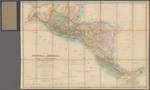
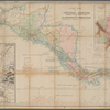
Lionel Pincus and Princess Firyal Map Division, The New York Public Library. "Map of Central America including the states of Guatemala, Salvador, Honduras, Nicaragua & Costa Rica, the territories of Belise & Mosquito, with parts of Mexico, Yucatan & New Granada" The New York Public Library Digital Collections. 1850. https://digitalcollections.nypl.org/items/3be29ec0-cbf4-0132-788f-58d385a7bbd0
Lionel Pincus and Princess Firyal Map Division, The New York Public Library. "Map of Central America including the states of Guatemala, Salvador, Honduras, Nicaragua & Costa Rica, the territories of Belise & Mosquito, with parts of Mexico, Yucatan & New Granada" New York Public Library Digital Collections. Accessed April 27, 2024. https://digitalcollections.nypl.org/items/3be29ec0-cbf4-0132-788f-58d385a7bbd0
Lionel Pincus and Princess Firyal Map Division, The New York Public Library. (1850). Map of Central America including the states of Guatemala, Salvador, Honduras, Nicaragua & Costa Rica, the territories of Belise & Mosquito, with parts of Mexico, Yucatan & New Granada Retrieved from https://digitalcollections.nypl.org/items/3be29ec0-cbf4-0132-788f-58d385a7bbd0
<ref name=NYPL>{{cite web | url=https://digitalcollections.nypl.org/items/3be29ec0-cbf4-0132-788f-58d385a7bbd0 | title=
(cartographic)
Map of Central America including the states of Guatemala, Salvador, Honduras, Nicaragua & Costa Rica, the territories of Belise & Mosquito, with parts of Mexico, Yucatan & New Granada, (1850)
|author=Digital Collections, The New York Public Library |accessdate=April 27, 2024 |publisher=The New York Public Library, Astor, Lenox, and Tilden Foundations}}</ref>