Click to visit the main New York Public Library Homepage
The New York Public Library
Digital Collections
About Digital Collections
Browse
Search only public domain materials
Items
Collections
Divisions
Home
Search
Browse
About
Search only public domain materials
Items
Collections
Divisions
Digital Collections
Using Images
Using Data
Search
Filtered search
Show filters
Hide filters
Show Only Public Domain
topic
Real property
567
Landowners
376
Administrative and political divisions
72
Real propery auctions
67
Railroads
25
More
Less
name
G.W. Bromley & Co
52
Bourquin, F. (Frederick), 1808-
34
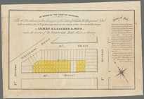
James Bleecker & Sons
34
Robinson, E. (Elisha)
31
A.H. Mueller (Publisher)
29
More
Less
collection
Maps of North America
292
Maps of New York City and State
183
Collection of broadside real estate maps announcing auctions of lots in early 19th century New York City
67
Atlases of New York City
52
Atlases of the United States
29
More
Less
place
New York (State)
247
New York
103
Manhattan (New York, N.Y.)
84
New York (N.Y.)
77
United States
69
More
Less
genre
x
Cadastral maps
Maps
624
Atlases
29
Manuscript maps
29
Illustrations
13
More
Less
publisher
publisher not identified
98
G. W. Bromley & Co
52
A.H. Mueller
29
Published by Warner & Foote
22
J.B. Beers & Co
7
More
Less
division
Map Division
594
Milstein Division
29
Manuscripts and Archives Division
1
No Division
1
type
cartographic
619
still image
20
text
12
Date Range
to
625 results found
Filtering on:
x
Genre
: Cadastral maps
x
Rights
: Public Domain
Sort by:
Title
Date created
Date digitized
Sequence
13 lots of ground to be sold …
m
1750-1753
180 lots on the Marsellis Tra…
m
3 three story brick houses in…
m
51 lots to be sold by R.R. Mi…
A map of property belonging t…
A map of St. Augustine & vici…
A map of the original allotme…
A map of the original allotme…
A map of the town of New-ark …
A new map of the city of Buff…
A plan of Greenville, Norwich…
A plan of the land belonging …
A plan of the Manor of Philip…
A plan of the town of Pittsfo…
A plott of ye situations of t…
A topographical map of Lewis …
m
A topographical map of Lincol…
m
A topographical map of Lincol…
A topographical map of Steube…
m
Abbott's map of the city of M…
Allen's outline map of Ottumw…
m
Asher & Adams' new topographi…
Atherton, St. Lawrence County…
Atlas of the City of New York…
Atlas of the Oranges, Essex C…
m
Auction sale at Montrose Stat…
Block no. 86 : confidential r…
Block sketch 1679, New York C…
Bowery, Chrystie Street, Gran…
Broadway, Prince Street, Cros…
m
Brooklyn City Hall
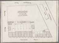
By order of the Court of Chan…
m
Castle Ridge, Tarrytown, West…
Cattaraugus Reservation of th…
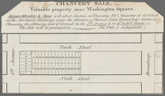
Chancery sale, Nov. 30th, 183…
Chancery sale, valuable prope…
Chase's ice map, showing loca…
Chicago : correctly copied fr…
m
Chicago
Chicago : with the school sec…
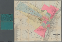
City of Albany, New York: fro…
City of Annapolis
City of Covington
City of Spokane Falls, Washin…
m
City of Toledo, Lucas Co., Oh…
m
Clark's map of Fairfield Coun…
Crocker's guide map of the ci…
Driving chart of Hartford and…
Duncan's addition to Michigan…
1
2
3
Previous
Next
1
2
3
Previous
Next