Click to visit the main New York Public Library Homepage
The New York Public Library
Digital Collections
About Digital Collections
Browse
Search only public domain materials
Items
Collections
Divisions
Home
Search
Browse
About
Search only public domain materials
Items
Collections
Divisions
Digital Collections
Using Images
Using Data
Search
Filtered keyword search
Show filters
Hide filters
Show Only Public Domain
topic
Administrative and political divisions
1
Lakes
1
Landowners
1
Nautical charts
1
Real property
1
name
Beers, F. W. (Frederick W.)
2
Balch, E. A
1
Colvin, Verplanck, 1847-1920
1
France. Dépôt des cartes et plans de la marine
1
French, J. H. (John Homer), 1824-1888
1
More
Less
collection
Atlases of the United States
2
Maps of New York City and State
2
Lawrence H. Slaughter Collection of English maps, charts, globes, books and atlases
1
place
Clinton County (N.Y.)
2
New York (State)
2
Adirondack Mountains (N.Y.)
1
Au Sable Forks
1
Au Sable Forks (N.Y.)
1
More
Less
genre
Maps
5
Atlases
2
Cadastral maps
1
publisher
Beers, Ellis & Soule
2
Adirondack Survey
1
Dépôt de la marine
1
W.O. Shearer & E.A. Balch
1
division
Map Division
5
type
x
cartographic
Date Range
to
5 results found for:
x
Au Sable (N.Y.)
Filtering on:
x
Type
: cartographic
Sort by:
Relevance
Title
Date created
Date digitized
Sequence
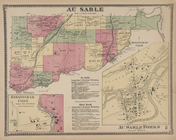
Au
Sable
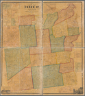
[Township
Map of Essex Co., New York
…. ; Clintonville [Village];
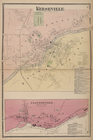
Au
Sable
Subscriber
Adirondack Survey, 1873, seco…
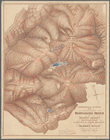
note:
… the
Au
Sable
River &c
Carte de la baye et riviere d…
note:
….
au
dégré W 74⁰20ʹ--W 73⁰50ʹ/
N
40⁰50ʹ--
N
40⁰25