


- The Library Shop
- Privacy Policy
- Rules and Regulations
- Using the Internet
- Website Terms and Conditions
- Gifts of Materials to NYPL
-
© The New York Public Library, 2024
The New York Public Library is a 501(c)(3) | EIN 13-1887440
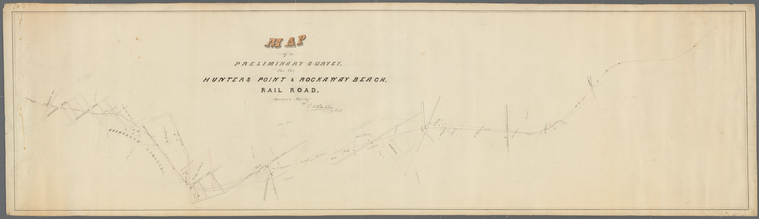
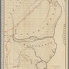
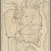
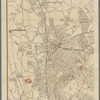
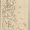
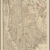
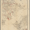
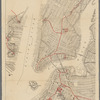
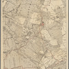
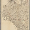
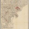
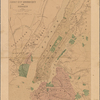
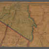
Lionel Pincus and Princess Firyal Map Division, The New York Public Library. "Map of a preliminary survey for the Hunters Point & Rockaway Beach Rail Road" The New York Public Library Digital Collections. 1867. https://digitalcollections.nypl.org/items/56b984e0-639f-0133-b5cd-00505686a51c
Lionel Pincus and Princess Firyal Map Division, The New York Public Library. "Map of a preliminary survey for the Hunters Point & Rockaway Beach Rail Road" New York Public Library Digital Collections. Accessed May 12, 2024. https://digitalcollections.nypl.org/items/56b984e0-639f-0133-b5cd-00505686a51c
Lionel Pincus and Princess Firyal Map Division, The New York Public Library. (1867). Map of a preliminary survey for the Hunters Point & Rockaway Beach Rail Road Retrieved from https://digitalcollections.nypl.org/items/56b984e0-639f-0133-b5cd-00505686a51c
<ref name=NYPL>{{cite web | url=https://digitalcollections.nypl.org/items/56b984e0-639f-0133-b5cd-00505686a51c | title=
(cartographic)
Map of a preliminary survey for the Hunters Point & Rockaway Beach Rail Road, (1867)|author=Digital Collections, The New York Public Library |accessdate=May 12, 2024 |publisher=The New York Public Library, Astor, Lenox, and Tilden Foundations}}</ref>