


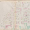

![Brooklyn, Vol. 1, Double Page Plate No. 1; Part of Wards 1, 2 & 4, Section 1; [Map bounded by Plymouth St., Marshall St., John St., Jay St., High St.; Including Cranberry St., Furman St., Fulton St., Water St., Dock St.]](https://images.nypl.org/index.php?id=1695479&t=b)
![Brooklyn, Vol. 1, Double Page Plate No. 2; Part of Wards 2 & 5, Section 1; [Map bounded by Little St., Evans St., Hudson Ave., Navy St.; Including Concord St., Jay St., Marshall St.]](https://images.nypl.org/index.php?id=1695480&t=b)
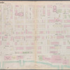
![Brooklyn, Vol. 1, Double Page Plate No. 3; Part of Wards 4 & 5, Section 1; [Map bounded by Prince St., Johnson St., Bridge St., Fulton St.; Including High St., Jay St., Concord St.]; Sub Plan; [Map bounded by Concord St., Navy St., Pork Ave., Hudson Ave.; Including Prince St., Johnson St., Fleet PL., Tillary St.]](https://images.nypl.org/index.php?id=1695481&t=b)
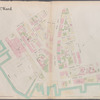
![Brooklyn, Vol. 1, Double Page Plate No. 4; Part of Wards 1, Section 1; [Map bounded by Atlantic Ave., Furman St., Columbia Heights; Including Cranberry St., Fulton St., Clinton St.]](https://images.nypl.org/index.php?id=1695482&t=b)
![Brooklyn, Vol. 1, Double Page Plate No. 5; Part of Ward 6, Section 2; [Map bounded by Atlantic Ave., Clinton St., Degraw St., Sedgwick St., Van Brunt St.; Including Baltic St., Warren St., Congress St., Amity St., Pacific St.]](https://images.nypl.org/index.php?id=1695483&t=b)
![Brooklyn, Vol. 1, Double Page Plate No. 7; Part of Wards 6 & 10, Section 2; [Map bounded by Hoyt St., 4th St., 3rd PL., Hemry St.; Including Degraw St., Clinton St., Warren St.]](https://images.nypl.org/index.php?id=1695485&t=b)
![Brooklyn, Vol. 1, Double Page Plate No. 8; Part of Wards 6 & 12, Section 2; [Map bounded by Degraw St., Henry St., Coles St., Seabring St., Van Brunt St., Commerce St.; Including Commercial Wharf Conover St., India Wharf, Hamilton Ave., Union St., Sackett St.]](https://images.nypl.org/index.php?id=1695486&t=b)
![Brooklyn, Vol. 1, Double Page Plate No. 9; Part of Ward 12, Section 2; [Map bounded by Commerce St., Seabring St., Columbia St., Dwight St., Dkeman St.; Including Wolcott St., Sullivan St., King St., Clinton Wharf, Commerce St.]](https://images.nypl.org/index.php?id=1695487&t=b)
![Brooklyn, Vol. 1, Double Page Plate No. 10; Part of Wards 6, 10 & 12, Section 2; [Map bounded by 3rd PL., Smith St., Gowanus Canal, Bush St.; Including Dwight St., Coles St., 4th PL.]](https://images.nypl.org/index.php?id=1695488&t=b)
- The Library Shop
- Privacy Policy
- Rules and Regulations
- Using the Internet
- Website Terms and Conditions
- Gifts of Materials to NYPL
-
© The New York Public Library, 2024
The New York Public Library is a 501(c)(3) | EIN 13-1887440
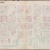
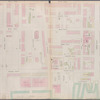
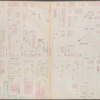
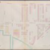
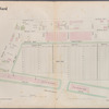
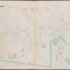
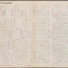
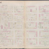
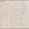
![Brooklyn, Vol. 1, Double Page Plate No. 6; Part of Wards 1, 3, 6 & 10, Sections 1 & 2; [Map bounded by Hoyt St., Warren St.; Including Clinton St., Fulton St.]](https://images.nypl.org/index.php?id=1695484&t=b)
Lionel Pincus and Princess Firyal Map Division, The New York Public Library. "Brooklyn, Vol. 1, Double Page Plate No. 6; Part of Wards 1, 3, 6 & 10, Sections 1 & 2; [Map bounded by Hoyt St., Warren St.; Including Clinton St., Fulton St.]" The New York Public Library Digital Collections. 1903 - 1907. https://digitalcollections.nypl.org/items/64b4acd6-f0fa-4e40-e040-e00a18063442
Lionel Pincus and Princess Firyal Map Division, The New York Public Library. "Brooklyn, Vol. 1, Double Page Plate No. 6; Part of Wards 1, 3, 6 & 10, Sections 1 & 2; [Map bounded by Hoyt St., Warren St.; Including Clinton St., Fulton St.]" New York Public Library Digital Collections. Accessed April 27, 2024. https://digitalcollections.nypl.org/items/64b4acd6-f0fa-4e40-e040-e00a18063442
Lionel Pincus and Princess Firyal Map Division, The New York Public Library. (1903 - 1907). Brooklyn, Vol. 1, Double Page Plate No. 6; Part of Wards 1, 3, 6 & 10, Sections 1 & 2; [Map bounded by Hoyt St., Warren St.; Including Clinton St., Fulton St.] Retrieved from https://digitalcollections.nypl.org/items/64b4acd6-f0fa-4e40-e040-e00a18063442
<ref name=NYPL>{{cite web | url=https://digitalcollections.nypl.org/items/64b4acd6-f0fa-4e40-e040-e00a18063442 | title=
(cartographic)
Brooklyn, Vol. 1, Double Page Plate No. 6; Part of Wards 1, 3, 6 & 10, Sections 1 & 2; [Map bounded by Hoyt St., Warren St.; Including  Clinton St., Fulton St.], (1903 - 1907)
|author=Digital Collections, The New York Public Library |accessdate=April 27, 2024 |publisher=The New York Public Library, Astor, Lenox, and Tilden Foundations}}</ref>
![Brooklyn, Vol. 1, Double Page Plate No. 6; Part of Wards 1, 3, 6 & 10, Sections 1 & 2; [Map bounded by Hoyt St., Warren St.; Including Clinton St., Fulton St.]](https://images.nypl.org/index.php?id=1695484&t=t)