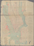
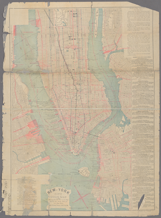
TitleNew guide map of New York City and Brooklyn with street directory
Additional title: New-York City guide map : showing business parts of Brooklyn, elevated rail roads, horse car and stage lines, hotels, churches, theatres, docks, piers, &cAdditional title: New map of the city of Brooklyn : showing the recent changes in the names of streets, route of the elevated rail road, location of the new Wallabout Market, and correcting many inaccuracies of other maps
NamesNew York & Eastern News Co. (Publisher)American Photo-Eng. Co. (Printer)
CollectionMaps of New York City and State
New York City
Manhattan
Dates / OriginDate Issued: 1891 (Questionable)Place: New York?Publisher: New York & Eastern News Co.,Place: N.Y.Publisher: American Photo-Eng. Co.
Table of ContentsNew-York City guide map : showing business parts of Brooklyn, elevated rail roads, horse car and stage lines, hotels, churches, theatres, docks, piers, &c. -- New map of the city of Brooklyn : showing the recent changes in the names of streets, route of the elevated rail road, location of the new Wallabout Market, and correcting many inaccuracies of other maps.
Library locationsLionel Pincus and Princess Firyal Map DivisionShelf locator: Map Div. 18-586
TopicsLocal transit -- New York (State) -- New YorkStreets -- New York (State) -- New YorkStreetsNew York (N.Y.)Brooklyn (New York, N.Y.)New York (State) -- New York
GenresMaps
NotesCitation/reference: New York Public Library. Dictionary catalog of the Map Division, v. 7, page 62, column a, row 1Content: Title from cover of accompanying text.Content: New-York City guide map includes text about rail and other transit lines as well as railroad stations.Content: New-York City guide map in 2 segments, with northern Manhattan segment at reduced scale. Segment covering southern Manhattan has color and shows radial distances in half-mile increments from City Hall.Content: Brooklyn map oriented with north to the upper left.Content: Scale approximately 1:18,500 (W 74°02ʹ50ʺ--W 73°54ʹ25ʺ/N 40°52ʹ55ʺ--N 40°39ʹ55ʺ).Content: Scale not given (W 74°01ʹ11ʺ--W 73°53ʹ58ʺ/N 40°44ʹ22ʺ--N 40°39ʹ13ʺ).
Physical DescriptionExtent: 2 maps on 1 sheet : both sides, part color ; sheet 72 x 53 cm, folded in cover + text (11, A-S pages ; 13 cm)
Type of ResourceCartographic
IdentifiersRLIN/OCLC: 1044710319NYPL catalog ID (B-number): b21607862Barcode: 33433087457051Universal Unique Identifier (UUID): 91ba6f60-3b7f-013b-b94b-0242ac110003
Rights StatementThe New York Public Library believes that this item is in the public domain under the laws of the United States, but did not make a determination as to its copyright status under the copyright laws of other countries. This item may not be in the public domain under the laws of other countries. Though not required, if you want to credit us as the source, please use the following statement, "From The New York Public Library," and provide a link back to the item on our Digital Collections site. Doing so helps us track how our collection is used and helps justify freely releasing even more content in the future.
Item timeline of events
-
-
-
-
-


![Central Park : memorial of the Common Council of the City of New York to the Legislature, approved June 11th, 1853...[title page]](https://images.nypl.org/index.php?id=5190254&t=b)