


![[blank page]](https://images.nypl.org/index.php?id=4053818&t=b)

- The Library Shop
- Privacy Policy
- Rules and Regulations
- Using the Internet
- Website Terms and Conditions
- Gifts of Materials to NYPL
-
© The New York Public Library, 2024
The New York Public Library is a 501(c)(3) | EIN 13-1887440
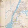
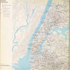
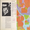
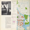
Lionel Pincus and Princess Firyal Map Division, The New York Public Library. "Manhattan community planning District 11. East Harlem, Randall's Island, Ward's Island." The New York Public Library Digital Collections. 1969. https://digitalcollections.nypl.org/items/c42cb93f-8f03-ca65-e040-e00a18064e5c
Lionel Pincus and Princess Firyal Map Division, The New York Public Library. "Manhattan community planning District 11. East Harlem, Randall's Island, Ward's Island." New York Public Library Digital Collections. Accessed May 1, 2024. https://digitalcollections.nypl.org/items/c42cb93f-8f03-ca65-e040-e00a18064e5c
Lionel Pincus and Princess Firyal Map Division, The New York Public Library. (1969). Manhattan community planning District 11. East Harlem, Randall's Island, Ward's Island. Retrieved from https://digitalcollections.nypl.org/items/c42cb93f-8f03-ca65-e040-e00a18064e5c
<ref name=NYPL>{{cite web | url=https://digitalcollections.nypl.org/items/c42cb93f-8f03-ca65-e040-e00a18064e5c | title=
(still image)
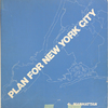
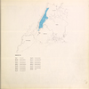
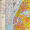
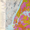
Manhattan community planning District 11. East Harlem, Randall's Island, Ward's Island., (1969)
|author=Digital Collections, The New York Public Library |accessdate=May 1, 2024 |publisher=The New York Public Library, Astor, Lenox, and Tilden Foundations}}</ref>