Click to visit the main New York Public Library Homepage
The New York Public Library
Digital Collections
About Digital Collections
Browse
Search only public domain materials
Items
Collections
Divisions
Home
Search
Browse
About
Search only public domain materials
Items
Collections
Divisions
Digital Collections
Using Images
Using Data
Collections
Charting America: Maps from the Lawrence H. Slaughter Collection and Others
Charting America: Maps from the Lawrence H. Slaughter Collection and Others
Navigation
Filters
Charting America: Maps from the Lawrence H. Slaughter Collection and Others
Previous
The south part of Virginia, now the north part of Carolina
0
Atlases, gazetteers, guidebooks and other books
377
Maps of the World
16
Maps of the Oceans
24
Maps of North and South America
23
Maps of North America.
551
Maps of New York City and State
1340
Lawrence H. Slaughter Collection of English maps, charts, globes, books and atlases
1020
John H. Levine Collection
60
More
Show filters
Hide filters
Show Only Public Domain
topic
x
History
Rivers
5
Fortification
2
Indians of North America
2
Lake George, Battle of, N.Y., 1755
2
More
Less
name
Hayward, George, approximately 1800-
3
Moore, George Henry, 1823-1892
3
Andrews, Ferdinand, 1802-1883
2
Blodget, Samuel, 1724-1807
2
G.W. Boynton & Co
2
More
Less
collection
Maps of New York City and State
16
Lawrence H. Slaughter Collection of English maps, charts, globes, books and atlases
1
place
New York (State)
14
United States
6
Hudson River Valley (N.Y. and N.J.)
4
Hudson River (N.Y. and N.J.)
3
New York
3
More
Less
genre
Maps
17
Facsimiles
2
Aerial views
1
Cadastral maps
1
Early maps
1
More
Less
publisher
publisher not identified
7
Ferdinand Andrews
2
Printed for Robt. Sayer and Jno. Bennett
2
A.S. Barnes & Co
1
Common Council
1
More
Less
division
Map Division
17
type
cartographic
17
Date Range
to
17 results found for:
x
Hudson River (N.Y. and N.J.)
Filtering on:
x
Topic
: History
Sort by:
Relevance
Title
Date created
Date digitized
Sequence
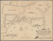
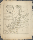
A mappe of Colonel Römers voy…
note:
… land from the
Hudson
River
to Cadragqua Lake
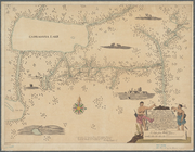
A mappe of Colonel Römers voy…
note:
… of the
Hudson
River
to Cadragqua
The seat of action between th…
topic:
Long Island, Battle of, New York,
N.Y
A prospective view of the bat…
abstract:
… ancillary map of the
Hudson
River
from New York
A prospective view of the bat…
note:
…"Copied from an engraving in the
N.Y
. State
A map of the country between …
Plan of West Point
note:
…, chain across the
Hudson
River
, and the 1st, 2nd
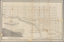
Map of Schuylerville: exhibit…
note:
… to Fish Creek and
Hudson
River
.
The seat of action between th…
topic:
Long Island, Battle of, New York,
N.Y
m
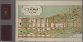
The Transval of New York
note:
… the Harlem and
Hudson
rivers
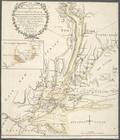
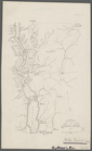
Operations on the
Hudson
River
topic:
Rivers
Operations on
Hudson
's
River
topic:
Rivers
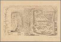
Attack on forts Clinton and M…
topic:
Rivers
Plan of the attack on forts C…
A sketch of the operations of…
note:
….,
N.Y
. for D.T
Plan von den Operationen der …
note:
… 74°01ʹ19ʺ--W 73°40ʹ28ʺ/
N
41°18ʹ00ʺ--
N
40°50ʹ56ʺ).
Position de l'armée Américain…
note:
D. Mc
N
. Stauffer Collection
End of results
|
Top