


![Central Park : memorial of the Common Council of the City of New York to the Legislature, approved June 11th, 1853...[title page]](https://images.nypl.org/index.php?id=5190254&t=b)


- The Library Shop
- Privacy Policy
- Rules and Regulations
- Using the Internet
- Website Terms and Conditions
- Gifts of Materials to NYPL
-
© The New York Public Library, 2024
The New York Public Library is a 501(c)(3) | EIN 13-1887440
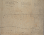
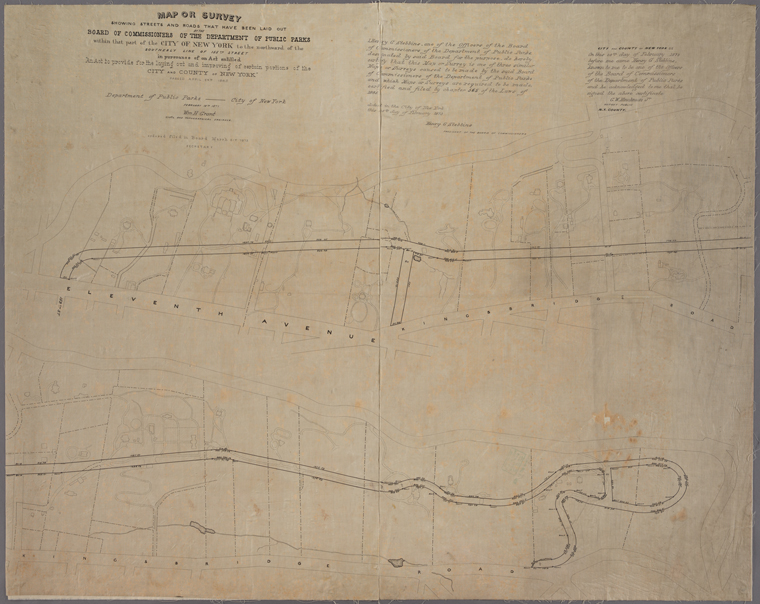
Lionel Pincus and Princess Firyal Map Division, The New York Public Library. "Copy of map or survey showing streets and roads that have been laid out by the Board of Commissioners of the Department of Public Parks within that part of the City of New York to the northward of the southerly line of 155th Street : in pursuance of an Act entitled "An Act to provide for the laying out and improving of certain portions of the City and County of New York" passed April 24th 1865 / Wm H. Grant, civil and topographical engineer." The New York Public Library Digital Collections. 1873. https://digitalcollections.nypl.org/items/4f4cf2f0-f3a2-0130-23a0-58d385a7b928
Lionel Pincus and Princess Firyal Map Division, The New York Public Library. "Copy of map or survey showing streets and roads that have been laid out by the Board of Commissioners of the Department of Public Parks within that part of the City of New York to the northward of the southerly line of 155th Street : in pursuance of an Act entitled "An Act to provide for the laying out and improving of certain portions of the City and County of New York" passed April 24th 1865 / Wm H. Grant, civil and topographical engineer." New York Public Library Digital Collections. Accessed April 26, 2024. https://digitalcollections.nypl.org/items/4f4cf2f0-f3a2-0130-23a0-58d385a7b928
Lionel Pincus and Princess Firyal Map Division, The New York Public Library. (1873). Copy of map or survey showing streets and roads that have been laid out by the Board of Commissioners of the Department of Public Parks within that part of the City of New York to the northward of the southerly line of 155th Street : in pursuance of an Act entitled "An Act to provide for the laying out and improving of certain portions of the City and County of New York" passed April 24th 1865 / Wm H. Grant, civil and topographical engineer. Retrieved from https://digitalcollections.nypl.org/items/4f4cf2f0-f3a2-0130-23a0-58d385a7b928
<ref name=NYPL>{{cite web | url=https://digitalcollections.nypl.org/items/4f4cf2f0-f3a2-0130-23a0-58d385a7b928 | title=
(cartographic)
Copy of map or survey showing streets and roads that have been laid out by the Board of Commissioners of the Department of Public Parks within that part of the City of New York to the northward of the southerly line of 155th Street : in pursuance of an Act entitled "An Act to provide for the laying out and improving of certain portions of the City and County of New York" passed April 24th 1865 / Wm H. Grant, civil and topographical engineer., (1873)
|author=Digital Collections, The New York Public Library |accessdate=April 26, 2024 |publisher=The New York Public Library, Astor, Lenox, and Tilden Foundations}}</ref>