


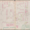
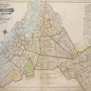
![Block Index. [Front]](https://images.nypl.org/index.php?id=1703615&t=b)
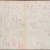
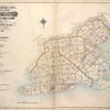
![Index to Streets. [Front]](https://images.nypl.org/index.php?id=1703616&t=b)
![Index to Streets - continued. [Front]](https://images.nypl.org/index.php?id=1703617&t=b)
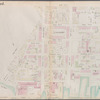
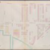
![Brooklyn, Vol. 1, Double Page Plate No. 1; Part of Wards 1, 2, 4 & 5, Section 1; [Map bounded by East River, Gold St., Hudson Ave., Little St.; Including Navy St., Johnson St., Pierrepont St.]; Sub Plan No. 1; [Map bounded by Hudson Ave., East River, U.S. Navy Yard; Including Little St., Marshall St.]](https://images.nypl.org/index.php?id=1703619&t=b)
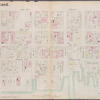
![Brooklyn, Vol. 1, Double Page Plate No. 2; Part of Wards 1, 3, 4 & 6, Section 1 & 2; [Map bounded by Pierrepont St., Johnson St., Bridge St., Hoyt St., Smith St.; Including Warren St., Baltic St., East River, Furman St.]](https://images.nypl.org/index.php?id=1703620&t=b)
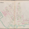
![Brooklyn, Vol. 1, Double Page Plate No. 3; Part of Wards 3 & 10, Section 1 & 2; [Map bounded by 4th Ave., 1st St., Lateral Canal, Cowanus Canal, 5th St.; Including Smith St., Bergen St., Hoyt St., Fulton St., Flatbush Ave.]](https://images.nypl.org/index.php?id=1703621&t=b)
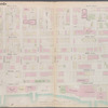
![Brooklyn, Vol. 1, Double Page Plate No. 4; Part of Wards 6, 10 & 12, Section 2; [Map bounded by Baltic St., Warren St., Smith St., 5th St., Gowanus Canal; Including 7th St., Nelson St., Columbia St., Hamilton Ave.]](https://images.nypl.org/index.php?id=1703622&t=b)
![Brooklyn, Vol. 1, Double Page Plate No. 5; Part of Ward 12, Section 2; [Map bounded by Gowanus Canal, Henry St. Slip, Halleck St., Erie Basin; Including Beard St., Dwight St., Nelson St., 7th St.]; Sub Plan no. 1 [Map bounded by Henry St., Gowanus Canal, Haleck St.; Including Hicks St., Bay St.]; Sub Plan no. 2 [Map bounded by Henry St., Gowanus Canal, Van Brunt St.; Including Beard St., Halleck St.]](https://images.nypl.org/index.php?id=1703623&t=b)
![Brooklyn, Vol. 1, Double Page Plate No. 7; Part of Ward 8, Section 3; [Map bounded by 5th Ave., 37th St., The Narrows; Including Gowanus Canal, Prospect Ave.]](https://images.nypl.org/index.php?id=1703625&t=b)
![Brooklyn, Vol. 1, Double Page Plate No. 8; Part of Ward 8, Section 3; [Map bounded by 2nd Ave., 37th St., 5th Ave., 49th St., Gowanus Bay]](https://images.nypl.org/index.php?id=1703626&t=b)
![Brooklyn, Vol. 1, Double Page Plate No. 9; Part of Ward 8, Section 3; [Map bounded by 49th St., 5th Ave., 60th St., The Narrows]](https://images.nypl.org/index.php?id=1703627&t=b)
![Brooklyn, Vol. 1, Double Page Plate No. 10; Part of Wards 8 & 30, Section 3; [Map bounded by 9th Ave., 49th St., 8th Ave.; Including 60th St., 5th Ave., 39th St.]](https://images.nypl.org/index.php?id=1703628&t=b)
![Street Index [Front]](https://images.nypl.org/index.php?id=1703768&t=b)
![Brooklyn, Vol. 3, Double Page Plate No. 1; Part of Wards 30, 31 & 32, Section 20; [Map bounded by Foster Ave., Avenue G, Ocean Ave.; Including Avenue K, Ocean Parkway, Grave Send Ave.]](https://images.nypl.org/index.php?id=1703770&t=b)
![Brooklyn, Vol. 3, Double Page Plate No. 2; Part of Ward 32, Section 23; [Map bounded by Glenwood Road, E. 14th St., Avenue K; Including Flatbush Ave., Ocean Ave.]](https://images.nypl.org/index.php?id=1703771&t=b)
![Brooklyn, Vol. 3, Double Page Plate No. 3; Part of Ward 32, Sections 23 & 24; [Map bounded by Glenwood Road, Paerdegat Ave., Ralph Ave.; Including Avenue K, E. 40th St.]](https://images.nypl.org/index.php?id=1703772&t=b)
![Brooklyn, Vol. 3, Double Page Plate No. 4; Part of Ward 32, Section 23; [Map bounded by Avenue K, Ralph Ave., Avenue O, Flatbush Ave.; Including Flatlands Ave., E. 37th St., Avenue E, E. 38th St., Hubbard PL., E. 40th St.]; Sub Plan; [Map bounded by Avenue K, E. 40th St., Hubbard PL.; Including E. 38th St., Avenue L, E. 37th St., Flatbush Ave.]](https://images.nypl.org/index.php?id=1703773&t=b)
![Brooklyn, Vol. 3, Double Page Plate No. 5; Part of Wards 31 & 32, Section 23; [Map bounded by Avenue K, E. 37th St., Flatlands Ave.; Including Avenue O, Ocean Ave.]](https://images.nypl.org/index.php?id=1703774&t=b)
![Brooklyn, Vol. 3, Double Page Plate No. 6; Part of Ward 32 - 31, Section 20; [Map bounded by Avenue K, Ocean Ave.; Including Avenue O, Gravesend Ave.]](https://images.nypl.org/index.php?id=1703775&t=b)
![Brooklyn, Vol. 3, Double Page Plate No. 7; Part of Ward 31, Section 20; [Map bounded by Gravesend Ave., Kings Highway, W. 6th St.; Including Avenue R, 22nd Ave., 58th St., Avenue M]](https://images.nypl.org/index.php?id=1703776&t=b)
![Brooklyn, Vol. 3, Double Page Plate No. 8; Part of Ward 31, Section 20; [Map bounded by Avenue O, Ocean Ave.; Including Avenue S, E. 2nd St.]](https://images.nypl.org/index.php?id=1703777&t=b)
![Brooklyn, Vol. 3, Double Page Plate No. 9; Part of Ward 31, Section 21-22; [Map bounded by Avenue S., Ocean Ave.; Including Avenue W, E. 2nd St.]](https://images.nypl.org/index.php?id=1703778&t=b)
![Brooklyn, Vol. 3, Double Page Plate No. 10; Part of Ward 31, Section 20-21; [Map bounded by Avenue R, W. 6th St., Kings Highway; Including E. 2nd St., Avenue U, Stillwell Ave.]](https://images.nypl.org/index.php?id=1703779&t=b)
![Brooklyn, Vol. 3, Double Page Plate No. 11; Part of Ward 31, Section 21; [Map bounded by Stillwell Ave., Bath Ave.; Including 23rd Ave.]](https://images.nypl.org/index.php?id=1703780&t=b)
![Brooklyn, Vol. 3, Double Page Plate No. 12; Part of Ward 31, Section 21; [Map bounded by Avenue U, E. 2nd St., Avenue W; Including Ocean Parkway, Avenue Z, Stillwell Ave.]](https://images.nypl.org/index.php?id=1703781&t=b)
- The Library Shop
- Privacy Policy
- Rules and Regulations
- Using the Internet
- Website Terms and Conditions
- Gifts of Materials to NYPL
-
© The New York Public Library, 2024
The New York Public Library is a 501(c)(3) | EIN 13-1887440
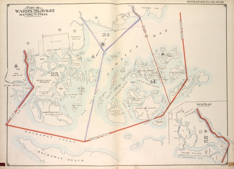
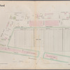
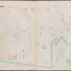
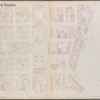
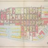
![Brooklyn, Vol. 3, Double Page Plate No. 38; Part of Wards 26, 31 & 32, Sections 14, 24 & 25; [Map bounded by Bedford Creek, Fresh Creek; Including Borough of Brooklyn, Carritsens Cree]; Sub Plan; [Map bounded by Garritsens Creek, Sheepshead Bay; Including Avenue x, Avenue W]](https://images.nypl.org/index.php?id=1703807&t=b)
Gravesend and Flatlands (31st and 32nd wards). 1920, Volume 3
Lionel Pincus and Princess Firyal Map Division, The New York Public Library. "Brooklyn, Vol. 3, Double Page Plate No. 38; Part of Wards 26, 31 & 32, Sections 14, 24 & 25; [Map bounded by Bedford Creek, Fresh Creek; Including Borough of Brooklyn, Carritsens Cree]; Sub Plan; [Map bounded by Garritsens Creek, Sheepshead Bay; Including Avenue x, Avenue W]" The New York Public Library Digital Collections. 1916 - 1920. https://digitalcollections.nypl.org/items/6c152750-a19d-6b6e-e040-e00a180611af
Lionel Pincus and Princess Firyal Map Division, The New York Public Library. "Brooklyn, Vol. 3, Double Page Plate No. 38; Part of Wards 26, 31 & 32, Sections 14, 24 & 25; [Map bounded by Bedford Creek, Fresh Creek; Including Borough of Brooklyn, Carritsens Cree]; Sub Plan; [Map bounded by Garritsens Creek, Sheepshead Bay; Including Avenue x, Avenue W]" New York Public Library Digital Collections. Accessed April 26, 2024. https://digitalcollections.nypl.org/items/6c152750-a19d-6b6e-e040-e00a180611af
Lionel Pincus and Princess Firyal Map Division, The New York Public Library. (1916 - 1920). Brooklyn, Vol. 3, Double Page Plate No. 38; Part of Wards 26, 31 & 32, Sections 14, 24 & 25; [Map bounded by Bedford Creek, Fresh Creek; Including Borough of Brooklyn, Carritsens Cree]; Sub Plan; [Map bounded by Garritsens Creek, Sheepshead Bay; Including Avenue x, Avenue W] Retrieved from https://digitalcollections.nypl.org/items/6c152750-a19d-6b6e-e040-e00a180611af
<ref name=NYPL>{{cite web | url=https://digitalcollections.nypl.org/items/6c152750-a19d-6b6e-e040-e00a180611af | title=
(cartographic)
Brooklyn, Vol. 3, Double Page Plate No. 38; Part of Wards 26, 31 & 32, Sections 14, 24 & 25; [Map bounded by Bedford Creek, Fresh Creek; Including Borough of Brooklyn, Carritsens Cree]; Sub Plan; [Map bounded by Garritsens Creek, Sheepshead Bay; Including Avenue x, Avenue W], (1916 - 1920)
|author=Digital Collections, The New York Public Library |accessdate=April 26, 2024 |publisher=The New York Public Library, Astor, Lenox, and Tilden Foundations}}</ref>
![Brooklyn, Vol. 3, Double Page Plate No. 38; Part of Wards 26, 31 & 32, Sections 14, 24 & 25; [Map bounded by Bedford Creek, Fresh Creek; Including Borough of Brooklyn, Carritsens Cree]; Sub Plan; [Map bounded by Garritsens Creek, Sheepshead Bay; Including Avenue x, Avenue W]](https://images.nypl.org/index.php?id=1703807&t=t)