Click to visit the main New York Public Library Homepage
The New York Public Library
Digital Collections
About Digital Collections
Browse
Search only public domain materials
Items
Collections
Divisions
Home
Search
Browse
About
Search only public domain materials
Items
Collections
Divisions
Digital Collections
Using Images
Using Data
Search
Filtered keyword search
Show filters
Hide filters
Show Only Public Domain
topic
Real property
298
Administrative and political divisions
178
Nautical charts
127
History
121
Railroads
112
More
Less
name
E.B. Hyde & Co
204
United States Coast Survey
139
Bache, A. D. (Alexander Dallas), 1806-1867
121
Hyde, Merritt B
118
Ullitz, Hugo
86
More
Less
collection
Maps of North America
846
Atlases of New York City
247
Atlases of the United States
177
Maps of New York City and State
70
Lawrence H. Slaughter Collection of English maps, charts, globes, books and atlases
40
More
Less
place
New York (State)
270
New York
159
Virginia
142
Pennsylvania
139
Suffolk County (N.Y.)
121
More
Less
genre
Maps
1454
Atlases
177
Nautical charts
117
Bathymetric maps
90
Cadastral maps
86
More
Less
publisher
E. Belcher Hyde
191
publisher not identified
92
U.S. Coast Survey
76
Sanborn Map Company
51
U.S. Coast Survey Office
42
More
Less
division
Map Division
1399
Manuscripts and Archives Division
24
Rare Book Division
10
Wallach Division: Print Collection
7
Schomburg Jean Blackwell Hutson Research and Reference Division
5
More
Less
type
x
cartographic
still image
44
text
33
Date Range
to
1,456 results found for:
x
17
Filtering on:
x
Type
: cartographic
Sort by:
Relevance
Title
Date created
Date digitized
Sequence
Results 1001 - 1050
To the citizens of Philadelph…
Sketch of the battle ground a…
Sketch showing the positions …
The route of the army under t…
The Matthews-Northrup up-to-d…
J.H. Colton's topographical m…
Charleston harbour, S. Ca. : …
parent:
d518e550-5438-0135-9eca-
17
dbc9a450cb
Rand, McNally & Co's standard…
Map showing the location of b…
m
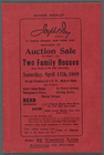
Auction Sale of thirty (30) T…
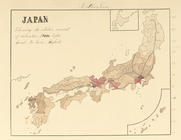
Japan, cultivation, showing t…
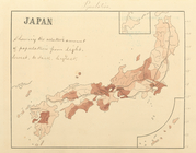
Japan, population, showing th…
m
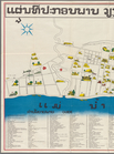
Tourist map of Vientiane
first:
57307e30-ef98-0137-f2f
1-7
fe0d1e97665
Geological survey of New York…
note:
Scale of maps 1-
17
: 1 mile to an inch.
Board of managers.
note:
Scale of maps 1-
17
: 1 mile to an inch.
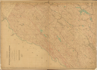
New Jersey, Double Page Sheet…
note:
Scale of maps 1-
17
: 1 mile to an inch.
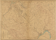
New Jersey, Double Page Sheet…
note:
Scale of maps 1-
17
: 1 mile to an inch.
New Jersey, Double Page Sheet…
note:
Scale of maps 1-
17
: 1 mile to an inch.
New Jersey, Double Page Sheet…
note:
Scale of maps 1-
17
: 1 mile to an inch.
Preliminary survey of the ent…
Chart of Narraganset Bay : su…
Preliminary sketch of Cherrys…
Topographical map of the stat…
Map of the canals and rail ro…
A geological and topographica…
m
New map of the city of Philad…
A compleat map of North-Carol…
Oregon
Lloyd's official map of the S…
Plan des achats des compagnie…
Appomattox Court House : from…
Map of Pittsburgh and Alleghe…
Map of the oil district of We…
Albemarle and Chesapeake Cana…
m
Map of Mahoning County, Ohio …
The key to East Virginia : sh…
m
Charleston District, South Ca…
Geological map of Berks Count…
Map of Richmond, Virginia and…
m
Wisconsin
Map of Roanoke, Virginia : th…
m
Post route map of the state o…
Map of Hon. Wm. L. Scott's es…
Sketch of Ocracoke Inlet, Nor…
Map of the city of Cleveland …
Map of the United States Terr…
Sketch of the public surveys …
m
City of Toledo, Lucas Co., Oh…
Map of Brooklyn at the time o…
Vermont, from actual survey :…
1
2
3
4
5
6
Previous
Next
1
2
3
4
5
6
Previous
Next