Click to visit the main New York Public Library Homepage
The New York Public Library
Digital Collections
About Digital Collections
Browse
Search only public domain materials
Items
Collections
Divisions
Home
Search
Browse
About
Search only public domain materials
Items
Collections
Divisions
Digital Collections
Using Images
Using Data
Search
Filtered keyword search
Show filters
Hide filters
Show Only Public Domain
topic
Real property
298
Administrative and political divisions
178
Nautical charts
127
History
121
Railroads
112
More
Less
name
E.B. Hyde & Co
204
United States Coast Survey
139
Bache, A. D. (Alexander Dallas), 1806-1867
121
Hyde, Merritt B
118
Ullitz, Hugo
86
More
Less
collection
Maps of North America
846
Atlases of New York City
247
Atlases of the United States
177
Maps of New York City and State
70
Lawrence H. Slaughter Collection of English maps, charts, globes, books and atlases
40
More
Less
place
New York (State)
270
New York
159
Virginia
142
Pennsylvania
139
Suffolk County (N.Y.)
121
More
Less
genre
Maps
1454
Atlases
177
Nautical charts
117
Bathymetric maps
90
Cadastral maps
86
More
Less
publisher
E. Belcher Hyde
191
publisher not identified
92
U.S. Coast Survey
76
Sanborn Map Company
51
U.S. Coast Survey Office
42
More
Less
division
Map Division
1399
Manuscripts and Archives Division
24
Rare Book Division
10
Wallach Division: Print Collection
7
Schomburg Jean Blackwell Hutson Research and Reference Division
5
More
Less
type
x
cartographic
still image
44
text
33
Date Range
to
1,456 results found for:
x
17
Filtering on:
x
Type
: cartographic
Sort by:
Relevance
Title
Date created
Date digitized
Sequence
Results 1251 - 1300
Survey of the entrance to Mil…
m
Topographical map of the stat…
New map of the city of Philad…
San Bernard River, Texas: sho…
m
Map of Madison County, Tenn. …
m
Post route map of the states …
Smyth County, Va.
Reconnaissance of Doboy Bar a…
m
Military map of the Indian Te…
Map of Cincinnati and suburbs…
Sketch of Beaufort, Port Roya…
Plan of a mineral estate situ…
Preliminary sketch of Mobile …
Preliminary chart of the sea …
Map of Cleveland and its envi…
Richardson's new map of the s…
m
Copy of section of photograph…
Copy of plate of Kenosha harb…
State of Michigan
Map of Perry County, Ohio
Map of revolutionary camp gro…
[Pla]n of the Siege of Yorkto…
Geological and topographical …
m
Map of Chickamauga & Chattano…
m
Title map of the coal field o…
Preliminary chart of Mount Ho…
Erie Harbor, Pa.
Sketch of Frying-Pan Shoals a…
Map showing the territory ori…
Preliminary chart of Cedar Ke…
Military map of south-eastern…
Indian Territory
Reconnaissance of Port Royal …
m
Copy of map of state of Flori…
Map of Wisconsin designed to …
m
Revised map of the state of T…
note:
Scale approximately 1:2,600,000 (W 105°
17
ʹ--W
Map of the Gogebic Iron Range…
m
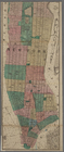
Map of the city of New York.
note:
Scale approximately 1:
17
,000. (W 74°01ʹ22ʺ--W
Carte des Etats-unis : provin…
m
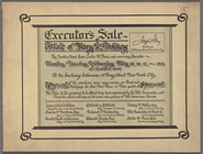
Executor's Sale: Estate of Ma…
General map of the anthracite…
Map of the centennial grounds…
Hydrographic map of Delavan a…
Geological map of the environ…
Map of the state of Kansas
Preliminary chart of the Rigo…
Whitney's map of Seattle and …
Grand Island Pass, Mississipp…
Metomkin Inlet, Virginia : fr…
Preliminary chart of Rappahan…
1
2
3
4
5
6
Previous
Next
1
2
3
4
5
6
Previous
Next