


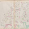
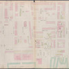
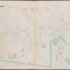
![Double Page Plate No. 1; [Map bounded by John St., Bridge St., East River, Little St.; Including Marshall St., Hudson Ave., Gold St.]](https://images.nypl.org/index.php?id=1695421&t=b)
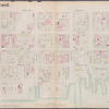
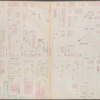
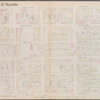
![Double Page Plate No. 2; [Map bounded by Bridge St., Plymouth St., Main St., East River, Washington St., Adams St.; Including John St., Pearl St., Jay St.]](https://images.nypl.org/index.php?id=1695422&t=b)
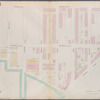
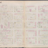
![Double Page Plate No. 3; [Map bounded by Main St., Water St., Fulton St., Furman St.; Including East River, Ferry to Fulton St. New York, Empire Stores]](https://images.nypl.org/index.php?id=1695423&t=b)
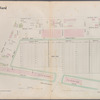
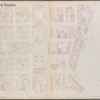
![Double Page Plate No. 4; [Map bounded by Furman St., Montague St. (Raised); Including Ferry to Wall St. New York, East River]](https://images.nypl.org/index.php?id=1695424&t=b)
![Double Page Plate No. 5; [Map boounded by Montague St. (Raised), Furman St., Atlantic St.; Including East River, Joralemon St., Ferry To Wall St. New York]](https://images.nypl.org/index.php?id=1695425&t=b)
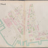
![Double Page Plate No. 6; [Map bounded by Atlantic St., Columbia St., Pacific St., Amity St., Congress St.; Including Waren St., Baltic St., Harrison St., Van Brunt St.]](https://images.nypl.org/index.php?id=1695426&t=b)
![Double Page Plate No. 8; [Map bounded by Hamilton Ave., Bowne St., Imlay St., Commerce St., Ewen St., Ferris St.; Including Wolcott St., Sullivan St., King St., North Pier St., South Pier St.]](https://images.nypl.org/index.php?id=1695427&t=b)
![Page Plate No. 9; [Map bounded by Conover St., Ferris St., King St.; Including Van Brunt St., Reid St.]](https://images.nypl.org/index.php?id=1695428&t=b)
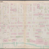
![Double Page Plate No. 10; [Map bounded by Irving St., Van Brunt St., Sedgwick St., Degraw St., Beach Place, Sackett St.; Including Ferry Place, Union St., Hamilton Ave., Partition St., Dikeman St., Ferris St., Wolcott St.]](https://images.nypl.org/index.php?id=1695429&t=b)
![Page Plate No. 11; [Map bounded by Atlantic Basin, Summit St., Gowanus Bay, Van Brunt St.; Including Erie Basin, Bowne St., Imlay St.]](https://images.nypl.org/index.php?id=1695430&t=b)
![Page Plate No. 12; [Map bounded by Ferris St., Columbia St., Furman St., Joracemon St.; Including Conover St., Partition St., Vandyke St., Irving St., Sedgwick St.]](https://images.nypl.org/index.php?id=1695431&t=b)
- The Library Shop
- Privacy Policy
- Rules and Regulations
- Using the Internet
- Website Terms and Conditions
- Gifts of Materials to NYPL
-
© The New York Public Library, 2024
The New York Public Library is a 501(c)(3) | EIN 13-1887440
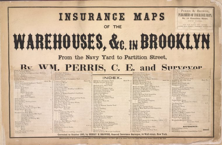
Insurance maps of the warehouses, &c., in Brooklyn from the Navy yard to Partition Street [1861]
Lionel Pincus and Princess Firyal Map Division, The New York Public Library. "Insurance maps of the Warehouses, &C. in Brooklyn from the Navy Yard to Partition Street," The New York Public Library Digital Collections. 1861. https://digitalcollections.nypl.org/items/64b486c0-128f-c1eb-e040-e00a18063e84
Lionel Pincus and Princess Firyal Map Division, The New York Public Library. "Insurance maps of the Warehouses, &C. in Brooklyn from the Navy Yard to Partition Street," New York Public Library Digital Collections. Accessed April 26, 2024. https://digitalcollections.nypl.org/items/64b486c0-128f-c1eb-e040-e00a18063e84
Lionel Pincus and Princess Firyal Map Division, The New York Public Library. (1861). Insurance maps of the Warehouses, &C. in Brooklyn from the Navy Yard to Partition Street, Retrieved from https://digitalcollections.nypl.org/items/64b486c0-128f-c1eb-e040-e00a18063e84
<ref name=NYPL>{{cite web | url=https://digitalcollections.nypl.org/items/64b486c0-128f-c1eb-e040-e00a18063e84 | title=
(text)
Insurance maps of the Warehouses, &C. in Brooklyn from the Navy Yard to Partition Street,, (1861)
|author=Digital Collections, The New York Public Library |accessdate=April 26, 2024 |publisher=The New York Public Library, Astor, Lenox, and Tilden Foundations}}</ref>
