+ o - ^
previous next

Nieuwe en nauwkeurige kaart van een gedeelte van Noord Amerika : behelzende Nieuw Engeland, New York, Pennsylvania, New Jersey, Connecticut, Rhode Island, een stuk van Virginia, Kanada en Halifax, ter opheldering der reizen van den Heer P. Kalm

More Details Cite This Item

View this item elsewhere:

Title
Nieuwe en nauwkeurige kaart van een gedeelte van Noord Amerika : behelzende Nieuw Engeland, New York, Pennsylvania, New Jersey, Connecticut, Rhode Island, een stuk van Virginia, Kanada en Halifax, ter opheldering der reizen van den Heer P. Kalm
Names
Kalm, Pehr, 1716-1779 (Author)
Mol, P. (Artist)
Huyser, C. J. de (Illustrator)
Brink, G. v. d. Jz. (Bookseller)
J. v. Schoonhoven & Comp. (Bookseller)
Collection

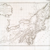
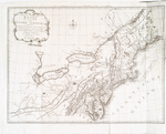
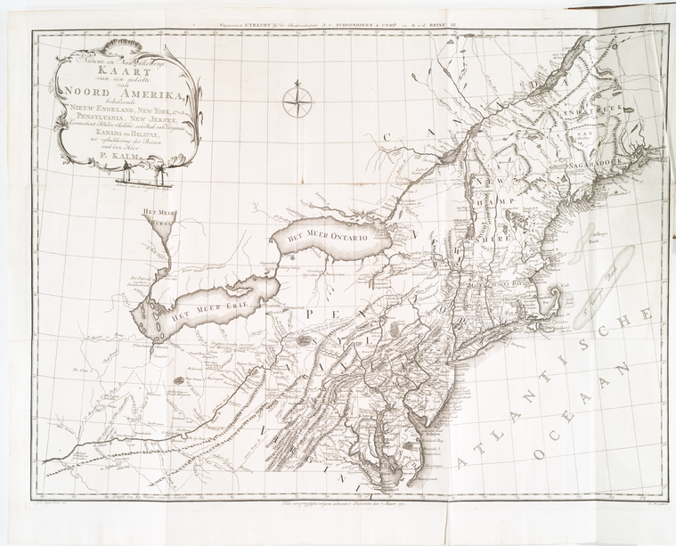
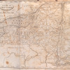
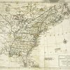
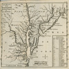
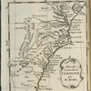
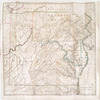
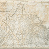
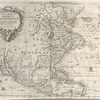
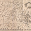
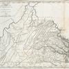
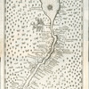
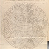
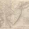
Lawrence H. Slaughter Collection of English maps, charts, globes, books and atlases

Atlases

Reis door Noord Amerika, gedaan door den Heer Pieter Kalm ... Vercierd met koperen platen ...

Dates / Origin
Date Issued: 1772
Place: Te Utrecht
Publisher: By J. van Schoonhoven en Comp. en G. van den Brink, Janz.
Library locations
Lionel Pincus and Princess Firyal Map Division
Shelf locator: Map Div. 97-6449 [LHS 3051, in atlas cases]
Shelf locator: Map Div. 97-6449 (Map facing p. 1) [In LHS 3051]
Topics
Canada -- Description and travel
Natural history -- Canada
Natural history -- United States
United States -- Description and travel -- Early works to 1800
Northeastern States
Northeastern States -- Maps -- Early works to 1800
Genres
Maps
Notes
Content: "Gedrukt ter Drukkerye van Dirk Kemink."
Content: Added illustrated t.-p., engraved by C. Philips Jacobsz.; plates engraved by C.J. de Huyser.
Content: Based on J.R. Forster's English, and J.A. and J.F. Murray's German translations of the Swedish original.--cf. translator's pref.
Content: Copy in Map Div. 97-6449 in Lawrence H. Slaughter Collection.
Content: Lawrence H. Slaughter Collection ; 3051.
Content: National Endowment for the Humanities Grant for Access to Early Maps of the Middle Atlantic Seaboard.
Ownership: Lenox.
Citation/reference: Sabin 36988
Content: "Het oorspronglyke volgens acte van't Parlement den 7 Maart 1771."
Content: Covers the area from Passamaquoddy Bay to Chesapeake Bay and west to Lake Erie.
Content: In upper margin: Uitgegeven te Utrecht by de Bockverkoopers J. v. Schoonhoven & Comp. en G. v. d. Brink, Jz.
Content: Lawrence H. Slaughter Collection.
Content: Relief shown pictorially.
Statement of responsibility: C.J. de Huyser, direx., 1772 ; P. Mol, geletterdt.
Physical Description
Extent: 1 map ; 55 x 74 cm. folded to 27 x 21 cm.
Type of Resource
Cartographic
Identifiers
RLIN/OCLC: 41963559
NYPL catalog ID (B-number): b14260402
RLIN/OCLC: 48997856
NYPL catalog ID (B-number): b15342396
Universal Unique Identifier (UUID): ad81e510-c5d4-012f-c43a-58d385a7bc34
Rights Statement
The New York Public Library believes that this item is in the public domain under the laws of the United States, but did not make a determination as to its copyright status under the copyright laws of other countries. This item may not be in the public domain under the laws of other countries. Though not required, if you want to credit us as the source, please use the following statement, "From The New York Public Library," and provide a link back to the item on our Digital Collections site. Doing so helps us track how our collection is used and helps justify freely releasing even more content in the future.

Item timeline of events

  • 1716: Creator Born
  • 1772: Issued
  • 1779: Creator Died
  • 2015: Digitized
  • 2024: Found by you!
  • 2025

MLA Format

Lionel Pincus and Princess Firyal Map Division, The New York Public Library. "Nieuwe en nauwkeurige kaart van een gedeelte van Noord Amerika : behelzende Nieuw Engeland, New York, Pennsylvania, New Jersey, Connecticut, Rhode Island, een stuk van Virginia, Kanada en Halifax, ter opheldering der reizen van den Heer P. Kalm" The New York Public Library Digital Collections. 1772. https://digitalcollections.nypl.org/items/ad81e510-c5d4-012f-c43a-58d385a7bc34

Chicago/Turabian Format

Lionel Pincus and Princess Firyal Map Division, The New York Public Library. "Nieuwe en nauwkeurige kaart van een gedeelte van Noord Amerika : behelzende Nieuw Engeland, New York, Pennsylvania, New Jersey, Connecticut, Rhode Island, een stuk van Virginia, Kanada en Halifax, ter opheldering der reizen van den Heer P. Kalm" New York Public Library Digital Collections. Accessed April 26, 2024. https://digitalcollections.nypl.org/items/ad81e510-c5d4-012f-c43a-58d385a7bc34

APA Format

Lionel Pincus and Princess Firyal Map Division, The New York Public Library. (1772). Nieuwe en nauwkeurige kaart van een gedeelte van Noord Amerika : behelzende Nieuw Engeland, New York, Pennsylvania, New Jersey, Connecticut, Rhode Island, een stuk van Virginia, Kanada en Halifax, ter opheldering der reizen van den Heer P. Kalm Retrieved from https://digitalcollections.nypl.org/items/ad81e510-c5d4-012f-c43a-58d385a7bc34

Wikipedia Citation

<ref name=NYPL>{{cite web | url=https://digitalcollections.nypl.org/items/ad81e510-c5d4-012f-c43a-58d385a7bc34 | title= (cartographic) Nieuwe en nauwkeurige kaart van een gedeelte van Noord Amerika : behelzende Nieuw Engeland, New York, Pennsylvania, New Jersey, Connecticut, Rhode Island, een stuk van Virginia, Kanada en Halifax, ter opheldering der reizen van den Heer P. Kalm, (1772) |author=Digital Collections, The New York Public Library |accessdate=April 26, 2024 |publisher=The New York Public Library, Astor, Lenox, and Tilden Foundations}}</ref>

Nieuwe en nauwkeurige kaart van een gedeelte van Noord Amerika : behelzende Nieuw Engeland, New York, Pennsylvania, New Jersey, Connecticut, Rhode Island, een stuk van Virginia, Kanada en Halifax, ter opheldering der reizen van den Heer P. Kalm