Click to visit the main New York Public Library Homepage
The New York Public Library
Digital Collections
About Digital Collections
Browse
Search only public domain materials
Items
Collections
Divisions
Home
Search
Browse
About
Search only public domain materials
Items
Collections
Divisions
Digital Collections
Using Images
Using Data
Search
Filtered search
Show filters
Hide filters
Show Only Public Domain
topic
Geography
141
History
92
Road maps
54
Nautical charts
50
Atlases, British
44
More
Less
name
Sayer, Robert, 1725-1794
61
Tiebout, Cornelius, 1777-1832
61
Colles, Christopher, 1738-1816
53
Cary, John, approximately 1754-1835
47
Faden, William, 1749-1836
46
More
Less
collection
Bancker plans
623
Lawrence H. Slaughter Collection of English maps, charts, globes, books and atlases
283
Maps of North America
188
Atlases, gazetteers, guidebooks and other books
70
Maps of New York City and State
46
More
Less
place
United States
153
Middle Atlantic States
75
North America
73
Great Britain
72
Maps
59
More
Less
genre
x
Maps
Surveys
622
land surveys
539
Documents
87
Prints
33
More
Less
publisher
Printed for John Cary
47
Printed for Robert Sayer, No. 53, Fleet-Street
44
Printed for J. Stockdale
25
publisher not identified
24
Imprimé à l'Université Imperiale de Moscou
22
More
Less
division
Manuscripts and Archives Division
631
Map Division
626
Rare Book Division
42
Wallach Division: Print Collection
28
General Research Division
14
More
Less
type
cartographic
1354
text
160
still image
10
Date Range
to
1,360 results found
Filtering on:
x
Date
: 1766 - 1794
x
Genre
: Maps
Sort by:
Title
Date created
Date digitized
Sequence
Results 251 - 300
m
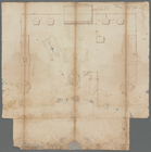
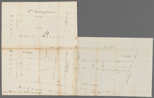
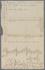
Minutes of Mr. Carley's land …
m
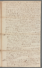
Surveys at Westchester
m
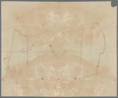
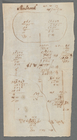
Survey of a tract of land
m
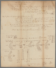
Horn's Hook for Abraham Duria
m
Hawken's and Wood's meadow
m
Mr. Yates's one lot King Stre…
m
Caleb Wood's farm
m
Survey of A. Van Horn's land
m
Water lots back of A. V. Cotl…
m
Daniel, Ebenezar Bowers's, an…
m
Garret Van Horne's house next…
m
Mr. Laight and Captain Rose's…
m
Leonard Lispenard's leased gr…
m
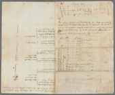
Table of a map to be annexed …
m
Thomas Smith's meadow
m
Estate of John Taylor and Cha…
m
Draft of the estate of the la…
m
Land adjoining Hudson River a…
m
Lots on Cherry Street and Wat…
m
Baskenridge
m
Calculations for Dr. Bard
m
Calculation of land for Mr. C…
m
Samuel Avery's land
m
Arthur's, Wheeler's, and Blan…
m
Arthur's Meadow
m
Alderman Dyckman's farm
m
Totten and Crossfield's divis…
m
R. G. Livingston's houses etc…
m
Surveys of Beaver Creek for J…
m
Part of Vermont
m
Ditches, fort and redoubt on …
m
Brooklyn Ferry
m
Division line between W. N. a…
m
Thomas Barn's land at Westche…
m
Peter Goelet's near the long …
m
James De Lancey's meadow
m
William Miller's whole real e…
m
N. Bayard
m
Thomas Smith's upland
m
Nassau Street, John Street, a…
m
The late John Quackenboss's e…
m
1793 March 10
m
Maps
m
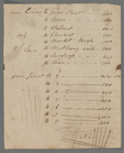
Land computations and notes
m
John Carpenter's lots
m
Susquehanna
m
Sherbrook
m
Fly Market water lots
m
Fletcher Street
m
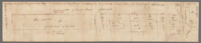
Fair Street
1
2
3
4
5
6
Previous
Next
1
2
3
4
5
6
Previous
Next