Click to visit the main New York Public Library Homepage
The New York Public Library
Digital Collections
About Digital Collections
Browse
Search only public domain materials
Items
Collections
Divisions
Home
Search
Browse
About
Search only public domain materials
Items
Collections
Divisions
Digital Collections
Using Images
Using Data
Search
Filtered search
Show filters
Hide filters
Show Only Public Domain
topic
Geography
141
History
92
Road maps
54
Nautical charts
50
Atlases, British
44
More
Less
name
Sayer, Robert, 1725-1794
61
Tiebout, Cornelius, 1777-1832
61
Colles, Christopher, 1738-1816
53
Cary, John, approximately 1754-1835
47
Faden, William, 1749-1836
46
More
Less
collection
Bancker plans
623
Lawrence H. Slaughter Collection of English maps, charts, globes, books and atlases
283
Maps of North America
188
Atlases, gazetteers, guidebooks and other books
70
Maps of New York City and State
46
More
Less
place
United States
153
Middle Atlantic States
75
North America
73
Great Britain
72
Maps
59
More
Less
genre
x
Maps
Surveys
622
land surveys
539
Documents
87
Prints
33
More
Less
publisher
Printed for John Cary
47
Printed for Robert Sayer, No. 53, Fleet-Street
44
Printed for J. Stockdale
25
publisher not identified
24
Imprimé à l'Université Imperiale de Moscou
22
More
Less
division
Manuscripts and Archives Division
631
Map Division
626
Rare Book Division
42
Wallach Division: Print Collection
28
General Research Division
14
More
Less
type
cartographic
1354
text
160
still image
10
Date Range
to
1,360 results found
Filtering on:
x
Date
: 1766 - 1794
x
Genre
: Maps
Sort by:
Title
Date created
Date digitized
Sequence
Results 751 - 800
m
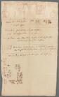
Description of Anne Depeyster…
m
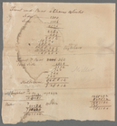
Englehart's given by Mr. Mill…
m
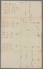
Protraction of land for Thoma…
m
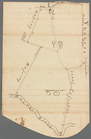
Varian's 105 acres in the man…
Plan of the siege of York Tow…
South-Carolina and parts adja…
A plan of the attack of Fort …
Sketch of the battle of Hobki…
m
An accurate map of North and …
A new and accurate map of Nor…
Plan of the battle fought nea…
Carte réduite des côtes et de…
Plan of the action at Huberto…
Position of the detachment un…
A map of such parts of Georgi…
Map of the Province of West F…
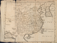
Map of China
m
New York City directory, 1792
m
A map of South Carolina and a…
m
A map of South Carolina : wit…
A plan of the attack of Fort …
m
New York City directory, 1793
A map of Kentucky from actual…
Plan of the siege of Savannah
Map of the state of Kentucky …
Carte d'une partie des côtes …
m
A chart of the harbour of Rho…
A Plan of the town of Newport…
A plan of the town of Newport…
A new and accurate map of the…
A new and accurate map of eas…
Plan of the action of Huberto…
A map of East and West Florid…
Map of New Haven and its envi…
Plan of the city of Washingto…
m
New York City directory , 179…
m
New York City directory, 1794…
A map of the province of Mass…
Coastal chart of the Massachu…
An accurate map of Rhode Isla…
Boston and the adjacent count…
Plan of part of the district …
An Accurate map of New Hampsh…
m
A map of the most inhabited p…
A new and accurate plan of th…
Plan of the town of Boston wi…
A plan of the battle, on Bunk…
A view of the rivers Kenebec …
m
Piscataqua Harbour, Portsmout…
A map of the country between …
1
2
3
4
5
6
Previous
Next
1
2
3
4
5
6
Previous
Next